

Basilan is an island province of the Philippines. It is the
largest and northernmost of the major islands of the Sulu Archipelago and is
located just off the southern coast of Zamboanga Peninsula. Its capital is
Isabela City.
Basilan is home to three main ethnic groups, the indigenous
Yakans, and the later-arriving Tausugs and Chavacanos. The Yakans and Tausugs
are predominantly Muslim, while the Chavacanos are mainly Christian.
There are
also a number of smaller groups.
Etymology
Oral traditions of the local Yakan people include several
names for pre-historic Basilan: "Uleyan", which is derived from the
present-named Basilan Peak (Puno Mahaji), and later changed to
"Matangal" after a mountain farther to the east of the island. These
names were presumably used by the Maguindanao traders from mainland Mindanao,
utilizing these mountains as navigational landmarks when sailing the Celebes
Sea. Other names romantically given were "Puh Gulangan" or
"island of forests", "Umus Tambun" or "fertile
land", "Kumalarang" after the westward flowing river on the
island's western half which is also otherwise called Baunuh Peggesan.
Taguima
Pre-Hispanic texts from the royal archives of the Sulu
Sultanate referred to the northernmost island of the Sulu Archipelago as
Taguima, from the Yakan who were called "Tagihamas" (people of the
interior or hinterlands) by the Tausug and Samal peoples who came and settled
in numerous but scattered communities along Basilan's western and southwestern shores
and outlying islets and island groups.
Later references mentioned "Bantilan", probably
referring to Maluso, which was established as a major Tausug base by Sulu
Sultan Muizz ud-Din (whose princely name was Datu Bantilan).
Imperial Chinese texts mention a "Kingdom of
Kumalarang" (from the Yakan "kumalang" or "to sing",
owing to the location being a place for celebrations and gatherings) during the
Ming Dynasty, believed to be the island which now has a barangay of the same
name on its northwestern shores.

The first Spanish map of Mindanao officially naming
"Basilan" island (instead of Taguima/Tagyma) by Nicolas Norton
Nicols, published in 1757.
The earliest map of the Philippines which made reference to
an island labeled "Taguima" was produced by Giacomo Gastaldi,[1]
through woodblock prints in 1548 and subsequently included in the influential
travel book of Giovanni Battista Ramusio, the Della Navigatione e Viaggi, which
was published between 1556 and 1583 in three volumes. This was followed by Abraham
Ortelius's work Indiae Orientalis Insularumque Adiacientium Typus, published in
1573 in a German text edition of the atlas Theatrum Orbis Terrarum by
Christophe Plantin in Antwerp. As late as 1719,[2] a map titled "Die
philippinische Inseln - Isle Brneo" by Allain Manesson Mallet of
Frankfurt, Germany featured an island still labeled "Tagyma I."
Basilan
The process by which all these names became
"Basilan" is almost certainly due to miscommunication between the
natives and the Spanish, as well as the penchant to engage in editorial license
by European map-makers of the era.
Basilan's name may also derive from its iron ore deposits.
Tausug warriors and slave-traders from Sulu came to Taguima to purchase
high-quality magnetic iron ores, which they used for swords, knives and other
blades. This profitable trade, helped in large measure by the establishment of
Maluso as a major military-naval base of the Sulu Sultanate, eventually gave
the island the distinction of being the source of basih-balan, the Tausug word
for magnetic iron. Roughly translated and abbreviated, however, basih-lan means
"the iron (magnet) trail" or "the iron way".
When several Tausug warriors were caught by the Spanish in
one of their numerous raids on the Zamboanga settlement, Spanish officials
supposedly admired the artistry and skill that went into making the warriors'
elaborately decorated swords, knives and blades, and asked where these weapons
could be bought. From atop the ramparts of the Spanish commandery at the Fuerza
del Nuestra Señora del Pilar de Zaragoza (Fort Pilar), the warriors supposedly
pointed to the island visible across today's Basilan Strait, and said, simply,
"ha basih-lan".
Reports from the Jesuit reducciones in Zamboanga and
Pasangen (Isabela) were relayed to Manila, where Spanish cartographer Pedro
Murillo de Velarde published Historia de la Provincia de Philipinas de la
Compañia de Jesvs. Segvnda parte using the Jesuit printing press at Manila in
1749. It featured a map of the Philippines with the as yet unofficial "I.
Basilan". The map was re-published by Leipzig map-maker Nicolaus Bellinn
for general European circulation in 1752.
Finally, to represent a clear break from the Habsburg
Dynasty (which had ruled Spain for 184 years from 1516 to 1700), the first
officially sanctioned Spanish maps of its colonies, including "Las Islas
de Mindanao", were commissioned by the Bourbons (1700–present). This
particular map of Mindanao, apparently copied from the Nicolaus Bellinn map of
1752, was published by Nicolas Norton Nicols in 1757, featuring
"Basilan" and bearing the royal stamp of Spanish Bourbon King
Ferdinand VI. It has been called "Isla de Basilan" (Basilan Island)
ever since.
Treasure Islands of the Southern Seas
Basilan Island's reputation as a staging-ground for Moro
raids on Zamboanga, the Visayas and even Luzon, and as a temporary repository
of the plunder from these raids. gave the island a notoriety not unlike the
"Treasure Islands" of the West Indies or the buccaneers' havens and
pirate coves of the Caribbean.
Spanish and Tausug fleets engaged each other in sea battles
and skirmishes not far from the western shores of the islands. Many of their
ships were scuttled or sunk, sometimes with precious cargoes of traded goods
and Mexican silver pieces meant for the fort in Zamboanga and the naval
squadron at Isabela, as well as goods en route to Jolo from the Mindanao
mainland.
The Spanish Pigafetta expedition landed on a group of islets
west of the main island of Basilan, where they found precious pearls;
subsequent Spanish cartographers aptly named these the "Isletas de
Perlas" (Pearl Islets). Native Samal and Bajao folk called this group of
islets and reefs "Pilas" (Perlas), a name still used to this day.
More recently, there have been local rumors about gold bars and other trinkets
hidden among the many islets by retreating Japanese troops at the end of World
War II. To date, treasure hunters of various nationalities, among them Japanese
and Europeans, have scoured the area.
All these tales of treasures hidden in Basilan's many
remote, unpopulated islets gave it the nickname "Treasure Islands of the
Southern Seas", immortalized in the official anthem of the Province of
Basilan, "Fair Basilan", composed by Basilan lyricist and composer
Tranquilino Gregorio.
Pre-Hispanic Taguima
Basilan's earliest settlers was traditionally believed to be
the Orang Dampuans originating from the islands of Eastern Indonesia, who are
supposed to be the ancestors of the native Yakans. They are variously called
the Orang Dyaks or the Tagihamas.
The Yakans, an inland pagan tribe, inhabited the Sulu Archipelago
together with the indigenous Sama and Bajau before the Malayan Tausug from
Sumatra and Borneo gained control of the area starting 300–200BCE.[3]
Historians have scant knowledge of the pre-Spanish history
of the indigenous Yakans simply because they have had little contact with other
ethnic groups. Basilan's nearness to Borneo led to the theory that the Yakan
originated from the Dyak. Although it is fairly safe to say that Basilan's
history is related to that of the Sulu archipelago, it is by no means right to
suppose that Basilan's first inhabitants came from Indonesia.

Human migration into the Philippines and Basilan
Recent anthropological and archaeological findings actually
point to a reverse pattern of human migration and subsequent habitation.
Originating from the region we know now as Southern China, some of the earliest
human communities constituting the northernmost dark-skinned branches of the
first or "southern" wave of human migrations from Africa, ancestors
of modern-day Aetas and Negritos, were forced to leave the area in the wake of
the arrival of the second wave of human migrants out of Africa, the
"northern" wave or the ancestors of present-day Chinese aboriginal
tribes. These short, dark-skinned and kinky-haired humans first found a home in
the relatively isolated island of Taiwan.
At about 5,000BCE, just as Earth was about to exit its most
recent ice age, a virtual explosion of human migration again ensued, this time
from Taiwan, traveling via land-bridges to Luzon in the Philippines, and
farther south. The first wave of these Austronesian migrants proceeded to
populate the greater and lesser Sunda islands of Borneo, Sulawesi, the
Moluccas, Java and Sumatra in Maritime Southeast Asia and make up the
Malayo-Austronesian branch of this population grouping. A more recent
sub-branch traveled across the Indian Ocean and populated the previously
uninhabited island of Madagascar off the southeast coast of Africa. The second
wave of Austronesians traveled eastwards from the Philippines, populating the
Western Pacific islands of New Guinea (Papua), Melanesia, Micronesia and
Polynesia.
Most of these negrito populations were eventually
assimilated through inter-racial mingling with Thai-Khmer populations moving
southwards from the Thai-Indochinese peninsula, the result being the Malayan
race that now inhabit Malaysia, Indonesia (Nusantara), and the Philippines. The
negrito populations of the western Pacific however, far removed from racial
inter-mingling from the Asian mainland, eventually evolved into the present
populations of New Guinea, Fiji, Hawaii and other Pacific island groups.
If Basilan itself was previously inhabited by these ancient
Negrito peoples, they were eventually driven farther south by the arrival at
around 1500BCE-500BCE of the same ancient Chinese-Annamese aboriginals who
drove away the Negritos from Southern China in the first place. Philippine
historians from the Spanish-era mistakenly called these new arrivals
"Indones" (Indian islanders) exhibiting physical features closer to
the ancient Chinese and Annamese. The lighter-skinned and relatively slimmer and
taller "Indones" communities eventually became the ancestors of
modern-day indigenous Philippine tribes populating nearly the entire Philippine
archipelago, the modern-day Lumads of the Philippines, and it is likewise
believed that the Yakans were descended from this same population grouping.
The general migratory pattern therefore of the original
inhabitants of the Philippine Archipelago follows a north-south path, contrary
to widely held beliefs based primarily on the more recent cultural
counter-migration which started from 300–200BCE.

This third and final wave of human migration came from the
general direction of Maritime Southeast Asia, albeit this time by full-fledged
Malays (from Borneo) who then promptly displaced indigenous tribes from their
coastal communities, driving the Indones or the Lumads farther inland, or south
and east into the eastern Indonesian islands. This particular migratory pattern
is seen in the pre-Hispanic legends of the 10 Datus from Borneo colonizing the
island of Panay, where a much older "Ati" (Aeta or Negrito) kingdom
graciously met them at their arrival. The migration of Malays into the
Philippines was accelerated by the development of the ancient thalassocratic
empires of the Malayo-Indian Sri Vijaya (from whom the name of the Visayas
islands are derived) and the Javanese Majapahit in the 12th–14th centuries.
Two main branches of this Malay invasion entered the
Philippine Archipelago via two separate routes. One, believed to have
originated from Sumatra and the Malay Peninsula, passed via the northern coast
of Borneo, and through Palawan and eventually settled by the banks of the river
Pasig in Luzon. These settlers soon branched into two tribes, the first became
known as the "people of the river" (or 'taga-ilog'/ Tagalog), which
developed a more sedentary, agricultural society built on the fertile plains
fed by the Pasig and around the area of Laguna Lake; while the second hugged
the shores of Manila Bay and therefore called the "people of the
coast" ('ka-pampang-an'/ Pampanga), primarily engaged in fishing.
Kapampangans eventually moved northwards into the interior of Luzon, and,
inter-marrying with indigenous 'highlanders' and visiting Chinese traders,
eventually produced the Iloko tribe. Tagalogs on the other hand, moved further
into the southeastern peninsula of Luzon, meeting up with the indigenous
communities there, as well as the "sea peoples of Visayas and
Mindanao". This produced the Bikol tribe.
The second and more recent main branch of Malays, believed
to come from Java and the Banjarmasin kingdom of southern Borneo, came by way
of the Sulu Archipelago, into Mindanao and up into the Visayas. These "sea
peoples" (so-called because they arrived to colonize the islands in their
various sea crafts, i.e. balotos, tilibaos, balasias, balangais, vireys, paraos
and caracoas), eventually branched further into two tribes: the Tau-Sug, which
settled in the Sulu Archipelago; and the Sug-bu-hanon which proceeded to
colonize Cebu (Sug-bo). A variety of intermingling between these two main
tribes, as well as indigenous tribes and aetas (as in the case of Iloilo and
the 10 Datus of Borneo), produced a plethora of other smaller tribes, i.e.
Hiligaynon, Waray in the Visayas, and the Maguindanao, Maranaw in Mindanao.
The Ifugao (of the Mountain provinces) and the Cuyunon
(Palawan), Mangyan (Mindoro) tribes are indigenous survivors of the northern
branch invasion. On the other hand, the Subanen (Zamboanga), Caraga
(Agusan/Surigao), Manobo (Cotabato), Higaonon (Lanao/Misamis), Sama/Bajau
(Sulu/Tawi-Tawi), and Yakan (Basilan) survived the southern branch invasion.
This pattern of initial habitation and subsequent
displacement by newer arrivals is clearly seen in the case of Basilan, where
the slim, tall, aquiline-nosed, and slit-eyed Lumad (Yakan) communities were
driven far inland and towards the eastern and northeastern coasts of the island
by the shorter, stockier and darker-skinned Malays (Tausugs) who proceeded to
occupy the island's western and northwestern coasts. (The same pattern was
repeated at the arrival of the Spanish and the Christian Malay
"Indios" from the Visayas and Luzon who were considerably taller and
lighter-skinned than the Muslim Malay "Moros", removing the latter to
the island's southeast enclave that they now dominate.)
Because the Philippine archipelago was successively
populated by two waves of negrito and ancient Chinese peoples before the rest
of Maritime Southeast Asia and the western Pacific were, it is widely presumed
that instead of the Yakans having descended from eastern Indonesian Dyaks, the
more logical conclusion would be that these eastern Indonesian Dyaks were
remnants of the "Indones" tribes fleeing from the Malays, some of
whom may even have been descended from the Yakan themselves.
Yakan Karajaan of Kumalarang
Records of pre-Hispanic Philippines gleaned from the
extensive archives of China's Imperial courts mentions a "Kingdom of
Kumalarang" located in one of the southern islands of Ma-yi (the Chinese
name for the Philippine archipelago), whose King sent regular tribute to the
Chinese emperor through Chinese traders who frequented the place in the 13th to
14th centuries. Local historians attribute this long lost kingdom to modern-day
Kumalarang (now reduced to a Barangay) located along the northwestern coast of
Basilan island.
Specifically, according to the Ta Min Hui Tien (Great Ming
compendium of laws), a report gleaned from the records of Tehchow, Shantung,
China (archived and researched in the years 1673, 1788 and 1935): 3 months
after the death of Paduka Batara (the Tausug potentate who visited the Chinese
Emperor Yung Lo and died on October 23, 1417), a High Court Mandarin, Chan
Chien, was ordered to sail to Kumalarang (Chinese texts refer to
"Kumalalang"), a vassal state of the Sulu Sultanate located on the
northwestern coast of Taguima (Basilan Is.).
Chan Chien was received by Lakan Ipentun (Ch. ref.
"Kanlai Ipentun"), presumably a Yakan Prince, who ruled the Kingdom
as a vassal to the Sultan of Sulu. The Mandarin official stayed in Kumalarang
for 2 years before returning to China.

He was accompanied by Lakan Ipentun and an entourage of
several hundred, composed of his immediate family, minor chieftains (datus),
and servants. They were finally given an audience with the Chinese Emperor on
November 16, 1420, where he formally asked the latter to proclaim him as a
recognized sovereign and vassal to the Dragon Throne.
Lakan Ipentun wrote a missive to the Chinese Emperor on
December 28, 1420, complaining about the time it took for the Chinese Emperor
to act on his request. The Chinese Emperor received the petition and finally
granted Lakan Ipentun with the title of "wang" (king). After his
request was granted, a satisfied Lakan Ipentun, along with his entire retinue,
started for home.
On May 27, 1421, however, unaccustomed to the cold climate
of the preceding winter and due to his advancing age, Lakan Ipentun died in Fujian,
China, just as they were about to embark on Chinese junks that would have
brought them home. His funeral was supervised by Yang Shan, administrator of
the temples, and was likewise honored by a eulogy sent by the Chinese Emperor
which extolled his virtues of "determination and serenity". His son,
Lapi, was then proclaimed as rightful successor to the just bestowed title of
"wang". Lapi sent one of his father's most trusted officials,
Batikisan, to petition for an audience with the Chinese Emperor where he
presented a "memorial" in gold plaque on November 3, 1424.
The party, with its newly proclaimed King, eventually
returned to Kumalarang, and almost just as promptly faded from the historical
records of the period.
Spanish era

Lesser coat of arms of Carles I of Spain (Charles V as Holy
Roman Emperor) used in the Spanish Empire dominions.
The first Europeans to ever document Basilan were the
remainder of the ill-fated Ferdinand Magellan expedition, led by Juan Sebastián
Elcano, and extensively documented by Italian scholar Antonio Pigafetta in the
later part of 1521. Fresh from the debacle in Mactan, and after having their
numbers reduced from 254 to less than a hundred scurvy-ridden sailors, the
Spanish party scoured the area of the Sulu Archipelago for a route to the
Moluccas (Spice Islands). After passing reefs and bountiful seaweeds, they came
to an archipelago, the main islands Pigafetta recorded as "the islands of
Zolo and Taghima (Sulu and Basilan) near which pearls are found". Food and
water were difficult to come by in this episode of their voyage, however, so
they eventually returned to Mindanao. The expedition eventually found its way
to the Moluccas and then finally returned to Spain. They were the first
Europeans to circumnavigate the world. Only 18 of them survived the long voyage
and made it back to Spain.
Upon the return of Adelantado Miguel López de Legazpi in
1565, and the establishment of the Spanish colonial government first in Cebu,
then in Iloilo and finally in Manila, the island of Basilan was gradually
colonized and settled, inducted as a Spanish possession as early as 1636,
formally organized as the 6th District of the Police-Military Government of
Mindanao by 1860, and completely pacified by 1886 - a period spanning exactly
250 years.
In September 1581, Msgr. Domingo de Salazar, O.P., the first
bishop of the islands, arrived in Manila. It was during his time and on his
initiative that an assembly of sorts was convened in 1582 on the lines of a
council, "to deal with matters concerning the furthering of the Faith and
the justification of past and future conquests by Spain".
The fathers of the council were of the opinion that no valid
claim could be laid to the conquest of the Philippines other than that based on
the right to preach the gospel, with the qualifying clauses, mentioned above.
But for this right to justify possession of territories, it was unnecessary to
depend on any direct opposition of the natives to the preaching of the gospel,
since the inferior or primitive organization of their government and of their
laws as would hinder or thwart their conversion was, in itself, sufficient
reason.

Standard of the Spanish Empire's explorers and
conquistadors, eventually becoming the flag of New Spain.
This theory of the Council of 1582 was unanimously accepted
by the religious of the Philippines, including Bishop Salazar.
Stemming from this Council's resolutions, real Spanish
authority spread over the islands hinged on the theory of "voluntary
submission" or "free consent" from the natives. Such a
consensual contract was institutionalized in the "cedula" imposed by
the Spanish government on all its subjects in the islands.
There is also the free consent given in 1845 by the
different chieftains of Basilan Island in Mindanao, who were contacted by the
governor of Zamboanga upon instructions to that effect given him by the then
Governor-General Narciso de Claveria. This free consent was construed as having
been represented by the issuance of "cedulas" to residents of Basilan.
It is noteworthy though, that in a later communication to
the central government in Spain, Governor Claveria corrected the earlier
erroneous information that Dato Usuk and the people of the Maluso region, in
the said island had given their consent. Governor Claveria made it clear that
such had not been the case, so the government was to refrain from exercising
any sovereignty over them. Such was the scrupulousness with which this matter
of free consent was regarded by Spain. Even as late as 1881 the same criterion
would be followed by the Spanish government.

The legendary Sultan Kudarat (Qachil Corralat to the
Spanish) of Maguindanao maintained lucrative trade routes between his mainland
kingdom and the Sulu Archipelago through a base situated in Lamitan. The
Maguindanaos then called the island "Matangal" after the highest
visible peak from the Celebes Sea. This base served as a staging ground for
much of Sultan Kudarat's offensives against the Spanish until the Spaniards
under the command of Governor General Sebastián Hurtado de Corcuera crushed it
in 1637, just one year after the Spanish Fort in nearby Zamboanga was
established. Spanish reports of the battle listed an Apuh Menggah, and Apuh
Dagang and Apuh Batalan as the main Yakan Chieftains leading the local
resistance at that time, all of whom were roundly defeated, prompting a
significant number of their followers to move farther inland and southwards.
The proselytization of Basilan started in earnest, however,
when Fr. Francisco Lado, a Jesuit, established the first Catholic mission, in
an area called Pasangen by the native Yakans. "Pasangen" is a Yakan
term for "commune", "town" or "a place where people
visit or stay". This coastal area, however, was already predominantly
populated by Tausug and Samal settlers when the Spanish came, and therefore was
likewise locally called a "pagpasalan" or "settlement
area". The Jesuit missionaries from Zamboanga arrived on the same year
that the removal of Sultan Kudarat's base from Lamitan was effected, and
established themselves in Pasangen on the island's northwestern coast. They
constructed the first wooden mission and palisade wall near the mouth of the
Aguada River, and dedicated the Island to St. Ignatius of Loyola, the founder
of the Jesuit order.
Pasangen then was ruled by three Tausug Chieftains, i.e.,
Datu Ondol, Datu Boto and Datu Kindingan. Through the efforts of the early
missionaries, supported by Don Pedro Palomino of the Zamboanga settlement, all
three were persuaded to be converted to Catholicism, with the last having been
baptized Luis Quindingan - the first Christian Basileño and anointed head of
the local principalía.
The Spaniards made several attempts to control Jolo, but
failed to do so until 1876. Basilan, however, was a wholly different story.
Catholic missionaries together with Spanish soldiers who inter-married into the
native population were able to successfully penetrate Basilan. So much so that
by 1654 there were about 1,000 Christian families living in the island.
Foremost among these pioneering families is the extended Lazaro Clan who, together
with its cadet branches, the Saavedra, Generalao, Suson, Pardo, Barrios and
Guevarra families, owned most of the cultivated lands that was to form part of
the growing Christian settlement.
Thus, the veil of Catholicism began to slowly spread across the
island with the spirited drive of the militant Jesuits. With no spices or gold
to enrich the Spanish king’s coffers, except for local taxes, the Jesuits
refocused the Spanish government's agenda and made religion the object of their
expansion and conquest here.
In anticipation of an invasion from the Chinese
pirate-warlord Koxinga, that was expected to devastate Manila, the Spanish
authorities withdrew all stations in the south of the country to augment their
forces holed up in Intramuros, temporarily freeing Zamboanga and Isabela from
direct Spanish administration in 1663.

Governor Sabiniano Manrique de Lara signed a decree on May
6, 1662, ordering the military evacuation of the fort in Zamboanga, and of
other Spanish colonies, including that of Ternate in the spice islands of the
Moluccas. Upon receipt of these orders on June 17, 1662, the Spanish garrisons,
along with a number of priests and their chosen local people started
preparations for the eventual evacuation. The garrison were given orders to
abandon the fort to the Christian Samas (progenitors of modern-day Chavacanos).
Such a move was vigorously opposed by the Jesuits, though, particularly by Rev.
Francisco Combes, SJ, even then, an acknowledged historian of Mindanao, but to
no avail. The Zamboanga fort was finally abandoned sometime in April 1663 by
the last remaining Spanish troops, they were evacuated and returned to Cavite
to help defend Manila's Intramuros from a threatened invasion by Chinese pirate
Koxinga, which never happened.
As fate will have it, the Chavacanos of Zamboanga and
Pasangen, Jesuits included, will amazingly endure another 56 years (1662–1718)
of isolated existence and proliferation amidst the hostile threat and return of
the Moro Pirates who overtook and destroyed the abandoned fort. In the face of
renewed threats from the surrounding Moro kingdoms of the area, the beleaguered
Christian native population of 6,000 including a number of Jesuit priests,
moved their settlement farther inland towards the area of modern-day Tetuan,
where a Jesuit mission dedicated to Saint Ignatius was built. The Jesuit
mission in Basilan, too, held out, albeit having its population drastically
reduced by the seemingly endless onslaught by hostile neighbors.
The Jesuits, belonging to the aggressive religious
expansionists' Society of Jesus, who remained in Zamboanga were historically
credited for petitioning Madrid for the reconstruction of the damaged fort in
1666, three years after the last Spanish soldiers vacated their walled post.
Spanish Queen Regent Maria Anna issued a cedula to the effect, but orders were
not carried out by the authorities in Manila. A second order to re-establish
the Fort was issued in 1672, but Gov. Diego de Salcedo again failed to carry
this out as well.
In the absence of Spanish Royal authorities the Jesuits
formed a sort of Christian city-state, called "reductions" (Spanish
Reducciones, Portuguese Reduções) in and around their 3-decade old Presidios
both in Zamboanga and Basilan. These were societies set up according to an
idealized theocratic model. The same type of communities were likewise
established by the Jesuits throughout South America, but especially in
present-day Brazil and Paraguay. The abandoned "reduccion" of some
1,000 Christian converts on the island of Basilan was thus placed under the
leadership of Luis Quindingan, designated as Camp Marshal and Chief by the
retreating Spanish garrison.
Although Koxinga died about a year after his veiled threat
to invade Manila, which caused the recall of Spanish troops to defend it, there
was no formal reason given as to why the Spanish government refrained from
returning their troops to Zamboanga soon after.
On January 17, 1673, an English freebooter, Capt. William
Dampier reached Tictabun island off the Zamboanga coast. There he wrote down
this account: "A little to the westward of the Keys (Tictabun island) we
saw an abundance of coconut trees, therefore we sent our canoes, thinking to
find inhabitants, but found none, no sign of any, but great tracks of wild hogs
and great cattle, and close by the sea were ruins of an old fort. The walls
thereof are of good height, built with stone and lime, and by the workmanship
seemed to be Spaniard."

Illustration of the Spanish palisade fortification and Jesuit
mission constructed at Pasangen, on the northwestern coast of Taguima
The year 1718 will change it all.
The Spanish royal authorities eventually returned in 1718.
Both the Tetuan and Basilan missions, however, held out against all odds.
Despite incessant attacks and raids by the Moros, the surviving Christian
populations of both missions still numbered over 3,000 by the time the Spanish
returned.
After having re-established lucrative trading agreements
with the native kingdoms that dotted the area, nearby Zamboanga experienced a
revival in its economy. The increasingly wealthy Spanish trading post in
Zamboanga became an even more sought after prize for the Moro pirates of the
era, so much so that the surrounding islands started to attract the attention
of other foreign powers, and chief among these coveted islands was Basilan.
Hostilities resumed in the 18th century, and this was
triggered by the decision in 1718 by Gov. Gen Juan Antonio dela Torre
Bustamante to reconstruct Real Fuerza de San José in Bagumbayan, Zamboanga. The
fort completed in 1719 was renamed Real Fuerza del Pilar de Zaragosa (Fort
Pilar is its popular name today). The rebuilt fort was inaugurated on 16 April
by Don Fernando Bustillos Bustamante Rueda, senior maestro de campo of
Zamboanga. Three years later in 1722, the Spaniards were launching another
expedition against Jolo. Led by Andres Garcia, the expedition failed miserably.

By then, Badar ud-Din, Sultan of Sulu, wo was keenly
interested in developing commercial ties with Manila and China, approached the
Spanish with a proposal of peace. According to the agreement they arrived at in
1726, the Spanish and Sulu were permitted to trade freely with each other and
the Island of Basilan was ceded to Spain. However, in a series of raids on the
Visayas, subjects of the Sultan broke the treaty which resulted in the renewal
of large-scale hostilities by 1730. [1] In 1731, General Ignacio Iriberri lead
a force of 1000 to Jolo and captured it after a lengthy siege. But the
Spaniards left after a few days.
In order to strengthen the Spanish position in Zamboanga and
the neighboring regions, three companies of native volunteers were organized in
1832. These natives together with the Spanish troops defended the town and the
province from the sporadic attack by the Moros.
In a slew of misnomers, the Spaniards mistakenly referred to
the Sultan of Sulu's subjects as Moros (Spanish for "Moors"). The
word Moor was derived from the ancient "Mauri/Maure" tribe of North
Africa, found in the ancient Roman Provinces of Mauretania Tingitana and
Mauretania Caesariensis. Today, the descendants of the Mauri/Maure - the
Berbers - continue to occupy the northwestern coasts of Africa, and are spread
throughout the countries of Morocco, western Algeria, and Mauritania, all of
which are North African countries just across the narrow western end of the Mediterranean
Sea from Spain, and peopled by Muslims which conquered and ruled Spain for 800
years. This explains the seemingly natural animosity felt by the Spanish
against the Muslim natives in these islands, especially coming from a
victorious war against Muslims for the reconquest ("Reconquista") of
the Iberian Peninsula from the Almohads and the Taifa Kingdoms which lasted for
centuries.
On the other hand, due primarily to their decidedly
Hindu-Buddhist influenced societies - having been long-time vassals of the
thalassocratic Hindu-Buddhist Sri Vijaya Empire - the non-Muslim native tribes
were then referred to by the Spanish as "Indios" (Spanish for
Indians), and called their colony in the far east, Las Indias Orientales
Españolas (or the "Spanish East Indies").
Half of the Zamboanga peninsula was made into a
Corregimiento (district) de Zamboanga with its jurisdiction reaching as far as
Sindangan to the north and the whole of Basilan island to the south, while the
northern half of the peninsula belonged to the District of Misamis. In 1837,
the government was changed to a Gobierno Militar. Zamboanga was made the
capital of Mindanao throughout the Spanish regime, except the period between
1872 and 1875, when the government was at Cottabato.

Flag of the Dutch East India Company or the Vereenigde
Oost-Indische Compagnie


Artist's illustration of the short-lived Dutch base of Port
Holland in Maluso, Basilan

The Dutch East India Company bombarded Jolo in 1744 and
attacked Basilan soon after, establishing a Dutch base which they called Port
Holland in 1746. They were eventually repulsed by Tausug warriors, sailing from
Sulu and led by a Tausug prince, Datu Bantilan. (The site of the short-lived
Dutch encampment is still called Port Holland, a coastal barangay of Maluso
town, to this very day.)
Towards the second part of the 18th century, pirate raids
from Sulu increasingly harassed the Spanish settlement in nearby Zamboanga,
usually using their heavily fortified base in Maluso as a staging ground for
some of their more successful forays. The Tausug raids reached a fevered
intensity by 1754. By this time, a flourishing kingdom of Yakans and Samals was
established in the area of modern-day Lamitan City. Headed by a loose
confederation of Datus (local tribal chieftains), called a Kadatuan, the Yakan
Confederacy traded with the Yakan communities farther inland.
In the meantime, the Jesuits were expelled from Portugal,
France, the Two Sicilies, Parma and the Spanish Empire in 1768. Jesuit missions
were very controversial in Europe, especially in Spain and Portugal, where they
were seen as interfering with the proper colonial enterprises of the royal
governments. The Jesuits were often the only force standing between the natives
and slavery. It is partly because the Jesuits protected the natives whom
certain Spanish and Portuguese colonizers wanted to enslave that the Society of
Jesus was eventually suppressed. The Recoletos de San Jose (Recollects) took
over territories previously assigned to the Jesuits.
In 1755, contingent of 1,900 men led by captains Simeon
Valdez and Pedro Gastambide was sent to Jolo to avenge for the raids by Sultan
Muiz ud-Din. But were roundly defeated. In 1775, after Moro raid on Zamboanga,
Capitan Vargas led a punitive expedition against Jolo but was repulsed.
Throughout this brief period, however, Catholic missionaries
continued their avid proselytization, converting entire clans of Subanen,
Samals, Yakans and Tausugs to Catholicism, adding to the growing Visayan
populations brought in primarily from Cebu and Panay.
Tausug Karajaan of Maluso


Royal Flag of the Sultanate of Sulu
Historical records about Basilan shifted then to the
archives found in the Royal courts of the maritime power that is right next
door - the Sulu Sultanate.
The sultanate of Sulu became a center of power in the 18th
century, ruled over the island of Basilan nominally, and had little influence
over the Yakan who were gradually driven far into the island's interior
(Sherfan 1976:11; Haylaya 1980:43).
It is widely assumed that by this time, Kumalarang has
either ceased to exist as a kingdom or was eventually broken up and its Yakan
inhabitants forced to migrate emmasse towards the hinterlands. The Yakans,
having retreated from any considerable direct contact with the invading
Tausugs, have retained their ancient animist beliefs in large measure, only
embracing Islam at a much later date.
Islam is said to have started in the Philippines in 1380 but
some scholars believe that Islam spread in some areas of the archipelago during
the early 13th century. Then and now, the inhabitants of the Sulu archipelago
have been described as Muslims who have retained much of their pre-Islamic
beliefs. Such folk-Islamic culture resulted from the fact that Islamic
conversions were mostly undertaken not by full-time religious teachers but by
Arab Muslim traders who traversed the Malacca–Borneo–Sulu–Luzon–Formosa route
(Sherfan 1976: 12–13).
By the early 18th century, the Sultan of Sulu had defeated
the Sultan of Maguindanao, signaling the rise of the Sulu sultanate in southern
Philippines, with Jolo as the seat of power. Some Yakan villages sent a yearly
tribute to the Sultan.
The Royal Archives of the Sulu Sultanate record that Sultan
Azim ud-Din I, son of Badar ud-Din, and who was known to the Spaniards and most
Tausugs as Alimuddin, ruled from 1735 to 1748. He was dethroned, exiled, then
returned as Sultan from 1764 to 1774. His father proclaimed him ruler of
Tawi-Tawi in 1735. In 1736, in a bid to cement the Sultanate's control over the
busy trade routes that criss-crossed the area, the new Sultan decided to return
his court from Dungun (Tawi-Tawi) to the old capital at Bauang (Jolo), which
was abandoned in 1638 when the Spanish armada under Gov. Gen. Sebastian Hurtado
de Corcuera attacked and occupied it until 1645.
However, distance from the powerful Datus at the court in
Tawi-Tawi made relations between them more and more tenuous. These Datus grew
increasingly hostile to Azim ud-Din I as the years progressed, having been seen
as a friend of the Spanish. They hatched a plot that would eventually lead to
Azim ud-Din's removal as Sultan in favor of his younger brother, who was known
to Spanish officials and missionary priests as Pangiran Bantilan or Datu
Bantilan. In 1748, Sultan Azim ud-Din was forced to leave Jolo for Taguima and
then Zamboanga. His younger brother, famed and respected for repulsing a Dutch
invading force in 1747, having been conferred his Royal name Muizz ud-Din, was
then proclaimed sultan.
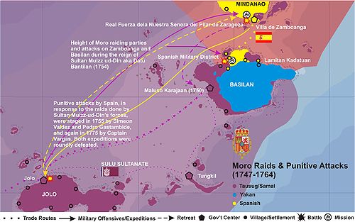
Still a strapping youth when he became a Sultan, Datu Bantilan ruled the Sultanate of Sulu for sixteen (16) violent though productive years (1748–1764), having vigorously promoted trade that linked Bauang (Jolo) with major trading ports straddling the Sulu Sea. He likewise launched several raids on the Spanish settlements in Zamboanga and the Visayas islands of Panay and Negros, and greatly profited from the slave-trade of captives taken from these raids which reached a fevered-pitch by 1754. He likewise repelled a Spanish attack consisting of some 1,900 soldiers sailing from Zamboanga.
In the meantime, Azim ud-Din, fearful that his enemies might
seek him out even in exile, sailed off to Manila where he remained for
sometime, relatively out of reach from his brother's lieutenants. His Manila
sojourn included a few years of imprisonment at Fort Santiago, as well as an
unconfirmed conversion to Catholicism.
To further strengthen his naval superiority in the Sulu Sea,
several Tausug warriors were sent to establish a base on the northernmost island
of the Sulu Archipelago, which until then was called Taguima, after the
Tagihamas (descended from the Orang Dyaks and ancestors of the modern-day
Yakans who are the acknowledged natives of the place). This base was built on
the island's southwestern coast facing Sulu, an area already thickly populated
by Tausug traders and fisherfolk. Maluso as it was called then, and is so to
this day, was the same site where the young Datu Bantilan met and vanquished
the Dutch, and razed their encampment at Port Holland, one year before he
became Sultan.
This Tausug base became a vital jump-off point for raids on
Zamboanga. As a major military naval base, Maluso was staffed with some of
Sulu's best blade-smiths and boat-builders to see to it that the Sultan's
raiders were properly equipped before any raid was launched. Slave-raids into
the island's interior likewise commenced.
As these raids became more and more frequent, the native
Yakans retreated farther and farther inland, away from the coasts which were
periodically harried by Datu Bantilan's Tausug warriors and slave-raiders. The
biggest and most advanced Yakan coastal settlement was located on the
northeastern shores of Basilan, in Lamitan, and far from the usual routes of
pirate raiders on their way to Zamboanga from Sulu and Maluso. The Yakans were
understandably wary of the Tausugs who proceeded to occupy much of the lowlands
of the island's southeast coast, and have remained hostile to the Tausug
kingdom that eventually flourished in the area.
After several successful incursions on Zamboanga were known
to originate from this new Tausug base, Spanish surveyors stationed in
Zamboanga took note of this and recorded Datu Bantilan's settlement, which by
then was conferred the formal recognition as a vassal kingdom of Sulu, the
Karajaan of Maluso.
Datu Bantilan died in the middle of 1763. His son, Azim
ud-Din II governed Sulu with his brother after the death of their father. By
the end of that year, he had become, for all practical purposes, the Sultan.


Azim ud-Din, now an old man, finally returned to Jolo in
1764 after Manila fell to the British. In the same year, on June 8, he was
formally reinstated to the throne by his British sponsors. In 1774, tired of
affairs of state, he formally handed over the throne to his son Muhammad
Israil. With the arrival of his uncle Azim ud-Din I from Manila in 1764, whom he
received well, Azim ud-Din II left his followers for Parang. Azim ud-Din II
returned in 1778 after his cousin's sudden death (which some claim was poisoned
by Azim ud-Din II himself), and was promptly proclaimed Sultan and reigned
until his death in 1791.
The British Navy in the Sulu Sea


The Naval Ensign of the United Kingdom of Great Britain and
Ireland, standard of the world's most powerful navy in the mid-18th to mid-20th
centuries
In 1755, a contingent of 1,900 men led by captains Simeon
Valdez and Pedro Gastambide was sent to Jolo to avenge for the raids by Sultan
Muiz ud-Din, but were roundly defeated. In 1775, after a Moro raid on
Zamboanga, Capitan Vargas led a punitive expedition against Jolo but was
repulsed.
The second half of the 18th century saw a new player in the
Sulu Zone. After occupying Manila from 1762 to 1764, during the Thirty Years'
War between Spain and England, the British withdrew south. There they
established trading alliances between the Sulu Sultanate and the British East
India Company. Spanish attacks on Jolo were now directed at weakening British
trading interests in the south. In 1784, Aguilar conducted a series of
unsuccessful assaults against Jolo and in 1796, Spanish Admiral Jose Alava was
sent from Madrid with a powerful naval fleet to stop slave-raiding attacks
coming from the Sulu Sea. British presence was signaled when in 1798, Fort
Pilar in Zamboanga was bombarded by the British navy, which had established a
base in Sulu. In 1803, the Lord Arthur Wellesley, governor-general of India,
ordered Robert J. Farquhar to transfer trading and military operations to
Balambangan island in Borneo. By 1805, the British had withdrawn its military
from Sulu.
1815 saw the end of the galleon trade with Mexico as the
wars of independence in the Americas was brewing. In 1821, administration of
the Philippines fell directly under Madrid after Mexico had become independent.
The Madrid government sought to end the “Moro threat.” In 1824, the Marina
Sutil, a light and maneuverable armada under Capitan Alonso Morgado encountered
the slave raiders in the Sulu Sea and routed the pirates, thus effectively
extending Spanish naval supremacy in an increasing area over the Sulu Sea. This
naval victory was followed by many more throughout the rest of the 19th
century, ultimately reducing the once-unchallenged Tausug navy to a shadow of
its former self.
The French blockade


Adm. Jean-Baptiste Thomas Médée Cécille.

Jules Dumont d'Urville (1846). Voyage au Pôle Sud et dans
l'Océanie sur les corvettes L'Astrolabe et La Zélée exécuté par ordre du Roi
Pendant les Années 1837–1838–1839–1840 sous le commandement de M.
Dumont-d'Urville. Atlas pittoresque. [Journey to the South Pole and Oceania on
the Corvettes L'Astrolabe and La Zélée to Execute the Order of the King during
the Years 1837–1838–1839–1840 under the Command of Dumont d'Urville. Pictorial
Atlas.]. Paris: Gide.
By the 1840s, colonial interests other than Spanish focused
over western Mindanao, particularly the territories under the Sulu sultanate.
The British, French, Germans, and Americans all became interested in these rich
islands.
In 1843, the French Foreign Minister François Guizot sent a
fleet to Vietnam under Admiral Cécille and Captain Charner,[4] which started
the French intervention in Vietnam. The move responded to the successes of the
British in China in 1842, and France hoped to counterbalance these successes by
accessing China from the south. The pretext however was to support British
efforts in China, and to fight the persecution of French missionaries in
Vietnam.[5] The fleet, accompanied by the diplomat Lagrene, tried to seize the
island of Basilan in order to create a base similar to Hong Kong, but projects
had to be abandoned following the strong opposition of Spain claiming the island
was part of the Philippines.[6]
When the French under Admiral Cécille blockaded Basilan in
1844–45,[7] an island which they called Taguime, intent on establishing a
network of naval stations to protect French trade in the area, the Spanish
governor protested that Basilan had recognized Spain's sovereignty just the
year before, in February 1844. The French then forced the Basilan datus to sign
a document affirming the “absolute independence of Basilan vis-a-vis Spain” on
January 13, 1845, aboard the steamer Archimede.


On February 20, 1845, France forced the Sulu Sultan to
formally cede Basilan Island to France in exchange for 100,000 piastres or
500,000 French francs. The French Admiral totally ignored Spanish protests.
However, the inhabitants of Basilan who remained loyal to Spain, fought against
the French for a year, forcing the French King, Louis Philippe, also a Bourbon,
to ultimately decide against taking Basilan although the French Cabinet already
approved the annexation, even allocating the budget for Basilan for that year.
France's claims on Basilan were based on a formal cession
from the Sultan of Sulu as well as formal written agreement from the Basilan
datus. These claims were eventually withdrawn by France, formalized in a
proclamation dated August 5, 1845, turning over full sovereignty of the island
to Spain. During the same year, a US survey mission studied the potentials of
the Sulu archipelago, but American intervention did not start until 1899.
Fuerte de la Reina Isabel Segunda

Coat of arms of Isabella II and other Spanish Monarchs of
the House of Bourbon from 1761 to 1931.

Isabella II, Queen of Spain and the Indies, reigned from
September 29, 1833 (forced to leave Spain: September 30, 1868; abdicated in
favor of her son: Paris, June 25, 1870)
After two centuries of incessant and unrelenting raids and
counter-raids, the fortunes of the Spanish Empire in the Sulu Archipelago took
a dramatic turn for the better in 1848, primarily due to three watershed
events: (1) the advent of Spain's steam-powered naval superiority over Sulu's
outrigger-and-sail paraws; (2) the fall of Sulu's Balangingi allies on Tungkil;
and, (3) the establishment of Fuerte Isabel Segunda or Fort Isabella Segunda on
Basilan Island. These three benchmarks sparked off a series of events which,
from 1848 on, saw Sulu's power wane until it was finally blighted and almost
completely snuffed out on the eve of the American occupation.
To check the inroads of both the increasingly bloody Tausug
pirate raids and the growing influence of Lamitan's Yakan kingdom, as well as
to thwart any further attempt by other European powers to colonize Basilan (the
Dutch in 1747 and the French in 1844) the Spanish commandery in Zamboanga City
sent over an expeditionary force tasked at establishing Spanish fortifications
on Basilan island, both to serve as an early beacon and defensive perimeter
against the pirate parties, and as a trading post for Spanish interests on the
island.
In 1845, Don Ramon Lobo, the Marine Chief of Zamboanga,
accompanied Don Cayetano Suarez de Figueroa, District Governor of Zamboanga, to
the coastal settlement of Pasangen. Wooden fortifications were initially
erected on the settlement's highest point facing the narrow channel about 800
meters from the shore. The 200-year-old Jesuit mission was situated half-way
between the fort and the shore. The fortification proved to be easily
defensible as nearby Malamawi Island blocked direct attacks and raids from the
sea. Later that same year, Governor Narciso Claveria ordered the construction of
a stone fort, following the plan of engineer Emilio Bernaldez submitted in
1844. Construction lasted four years.
By 1848, the stone fort was finished, replacing the wooden
fortifications. In the meantime a sizeable and growing Christian settlement
continued to flourish around the Recollect mission, rededicated since the
expulsion of the Jesuits, to St Isabel de Portugal (Elizabeth of Portugal). The
Fort thus established was subsequently named in honor of Queen Isabella II of
Spain and the Indies, and was named Fuerte de la Reina Isabel Segunda. The
military garrison was initially placed under the direct command of the Fuerza
de Nuestra Señora del Pilar de Zaragosa (Fort Pilar) in Zamboanga.

Illustration of Fort Isabella Segunda, Basilan Island,
Philippines, current site of the Basilan Provincial Capitol at Isabela City,
Basilan.
Nieto Aguilar (1894) describes the fort as “magnificent”.
Situated 20 meters above sea level, the fortification overlooked the two
entrances to the bay, formed by Basilan and Malamawi Island. To the fort's east
were the barracks. The fort had four bastions at the corner of its rectangular
perimeter. It enclosed a well and had four structures for the corps of guards,
the garrison personnel, the presidio, jail, artillery corps and the casa
comandancia.
In the fort was the governor’s residence as well as that of
his officials. It was also a naval station where the navy maintained small
workshops for urgent repairs. It had a storehouse for coal near the shore.
Total personnel: two officer, 50 men.
Outside the fort were built other structures, namely: a
military infirmary, school, ayuntamiento (city hall), corps of engineers'
building, storehouses and dependencies of the naval station, barracks for the
marine infantry, gunpowder storehouse, and the Jesuit church and convent.
To further cement the presence of the missionaries in the
area, the Augustinian Recollects, under the leadership of Padre Jose Riboste
finally built a Church on the site of the old mission, situated opposite the
stone fort and across a grassy Plaza nearly halfway between the fort and the
shoreline. The Church was completed in 1850, and quickly became the locus of
the fledgling Christian town which then grew around it.
In 1848, Gov. Gen. Narciso Claveria with powerful gunboats
Magallanes, El Cano, and Reina de Castilla brought from Europe supervised the
attack on Balangingi stronghold in Tungkil. The raid resulted in the capture of
many Sama Balangingi and the exile of many to the tobacco fields of Cagayan
Valley. However, the leader of the Sama, Panglima Taupan, was not captured. He,
along with his closest ally Datu Jalaban Dasido, fled northwards to Basilan,
where they hied off, hoping to be able to spring a counter-attack and recoup
their tremendous losses. However, with the fall of the Balangingi, a powerful
ally of the Sulu Sultanate was decimated, this started the downturn of the
sultanate’s maritime sea power.

The continuing difficulty posed by the Tausug Karajaan in
Maluso to Spanish interests on Basilan exemplified by its willingness to enter
into treaties and agreements with other European powers, however, forced the
Spanish to rethink this policy of leaving Maluso essentially free from Spanish
rule. To ensure the unassailability of Spain's claims over Basilan, a
military-naval operation commenced to put an end to the enduring Maluso
Kingdom.
From the newly established Fort of Isabella Segunda and the
Spanish Naval headquarters also in Isabela, the Spanish forayed into the
erstwhile Tausug dominated area of Maluso with a band of Spanish and local
troops, attacked the Tausug base led by Zamboanga District Gov. Figueroa,
razing coastal Tausug and Samal towns along the way from Isabela. Upon the
defeat of the remaining forces of the Maluso Karajaan on May 31, 1849, an army
barracks was constructed beside a tree-lined plaza surrounded by a few houses.
Finally, after a Tausug counter-attack on Fort Isabela II was repulsed by the
Spanish garrison on September 29, 1849, wooden fortifications were built around
what eventually became known as the Maluso Poblacion, which during the American
era was renamed the Maluso Townsite.
Most of the Tausug and Samal nobility established by the
Sulu Sultanate withdrew from Maluso, preferring to return to Jolo and
Tawi-Tawi. The majority of the Tausug and Samal settlers, however, opted to
remain, even opening ultimately profitable trade relationships with both the
Spanish and the Christian indios in Zamboanga and Isabela.
Spanish raids were likewise carried out farther south and
towards the western tip of the island, resulting in the surrender of Tausug
chieftains Panglima Taupan and Datu Jalaban Dasido on July 16, 1857. Thus, the
Spanish effectively pacified nearly all of the Tausug and Samal settlements
along Basilan's western coasts.
By then, only the largely Yakan areas of Lamitan and the
interior remained outside of Spanish control.
As the situation in the island's western half started to
normalize, Christians and Tausugs likewise started a long-lasting
socio-political and economic alliance, which when used against the Yakans,
proved to be effective in advancing each other's interests for the next
century. This Christian-Tausug alliance was only broken in 1988, when a Yakan
was finally elected to the highest post in what became the Province of Basilan
for the very first time.
The Treaty of 1851
In 1850, Gov. Gen. Juan Urbiztondo continued with Claveria’s
campaign and annihilated the remaining Balangingi strongholds at Tungkil.
However, a raid on Jolo that same year was a failure. On 28 February 1851,
Urbiztondo launched another campaign against Jolo, destroying the whole town by
fire and confiscating 112 pieces of artillery.
On April 30, 1851, a treaty, otherwise known as the
"Act of Incorporation into the Spanish Monarchy" was signed between
the Spanish authorities and the Sultan of Sulu.

An 1858 German map of the Far East showing the limits of
"Spanish Possessions" (Spanische Besitzungen) in the area, clearly
including Basilan Island within the Spanish sphere even prior to the Fall of
Jolo in 1876.
"A solemn declaration of incorporation and adhesion to
the sovereignty of Her Catholic Majesty Isabella II, constitutional Queen of
Spain, and of submission to the Supreme Government of the Nation, made by His
High Excellency the Sultan of Sulu, Mohammed Pulalun, for himself, his heirs
and his descendants, Datus Mohammed Buyuk, Muluk, Daniel Amil Bahar, Bandahala,
Muluk Kahar, Amil Badar, Tumanggung, Juhan, Sanajahan, Na'ib, Mamancha and
Sharif Mohammed Binsarin, in the name and the representation of the whole
island of Sulu, to Colonel Jose Maria de Carlos y O'Doyle, politico-military
governor of the Province of Zamboanga, the islands of Basilan, Pilas, Tonkil,
and those adjacent thereto, as Plenipotentiary specially authorized by His
Excellency Antonio de Urbiztondo, Marquis of Solana, Governor and
Captain-General of the Philippine Islands."[2]
Don Pedro Gonzalez led an attack on Balanguingui on
September 28, 1853, to complete the depopulation of the area. It is during this
attack that Panglima Taupan and Datu Jalaban Dasido fled Balanguingui towards
Basilan, landing in the southern coast of Lantawan. Sustained searches across
the thick jungles of Basilan by Spanish authorities finally forced both Samal
Chieftains to surrender to the Spanish on July 16, 1857.
6th Politico-Military District of Mindanao


The Six Politico-Military Districts of Mindanao: Zamboanga
(red), Misamis (yellow), Surigao (orange), Davao (royal blue), Cotabato
(green), Basilan (navy blue)
On July 30, 1859, a royal decree was issued allowing the
Jesuits to recover their Missions in Mindanao from the Recollects.
A year after, on July 30, 1860, the Spanish government on
the Isla de Gran Molucas (Mindanao) was divided into six Police-Military
Districts, namely:
(1) Zamboanga (covering present-day Zamboanga City,
Zamboanga Sibugay and the southern part of Zamboanga del Norte up to Sindangan
Bay);
(2) Misamis (which covered the rest of Zamboanga del Norte,
Misamis Occidental, Misamis Oriental, Lanao del Norte, Bukidnon and the Cities
of Dipolog, Dapitan, Cagayan de Oro, Ozamiz, Oroquieta, Tangub and Iligan);
(3) Surigao (covering Agusan del Norte and Sur, and Surigao
del Norte and Sur, and the Cities of Butuan, Surigao and Tandag);
(4) Davao (covering all of the Davao Provinces, Davao City,
South Cotabato, Sarangani and the Cities of Koronadal, General Santos,Tacurong,
Tagum, Digos and Panabo);
(5) Cotabato (covering Zamboanga del Sur, Lanao del Sur,
Maguindanao, Sultan Kudarat, North Cotabato and the Cities of Cotabato and
Marawi); and
(6) Basilan (covering Basilan, Sulu, Tawi-Tawi and the
Cities of Isabela and Lamitan)
Fort Isabela Segunda became the focal point of the 6th
District of the Police-Military Government of Mindanao.
Thus, from 1860 until the end of the Spanish regime 39 years
later in 1899, the islands of Sulu and Tawi-Tawi and all of their outlying islets
were placed under the jurisdiction of Basilan, with its administrative capital
in Isabela.
By 1879, the Spanish fleet for the entire southern
Philippines was moved to Isabela, where a "floating" Naval Hospital
was built on shallows guarding the eastern entrance to the Isabela Channel. The
southern shore of nearby Malamawi Island became the repository of the coal used
by the Spanish steam-powered naval vessels, and has since been called Carbon
(currently a Barangay). Further to the east of the Isabela Channel, the Spanish
buried their war-dead on a small tongue of land off Malamawi's Panigayan coast,
this area was called Isla Calavera (Eng. Skeleton Island) until rising tides
completely submerged it.
The fall of Jolo
After a series of less-than-successful attempts during the
centuries of Spanish rule in the Philippines, Spanish forces captured the city
of Jolo, the seat of the Sultan of Sulu, in 1876.
On that year, the Spanish launched a massive campaign to
occupy Jolo. Spurred by the need to curb slave raiding once and for all and
worried about the presence of other Western powers in the south (the British
had established trading centers in Jolo by the 19th century, and the French
were offering to purchase Basilan Island from the cash-strapped government in
Madrid), the Spanish made a final bid to consolidate their rule in this
southern frontier. On 21 February of that year, the Spaniards assembled the
largest contingent against Jolo, consisting of 9,000 soldiers, in 11
transports, 11 gunboats, and 11 steamboats. Headed by Admiral Jose Malcampo
captured Jolo and established a Spanish settlement with Capt. Pascual Cervera
appointed to set up a garrison and serve as military governor; He served from
March 1876 to December 1876 followed by Brig.Gen. Jose Paulin (December 1876 –
April 1877), Col Carlos Martinez (September 1877 – February 1880), Col. Rafael
de Rivera (1880–1881), Col. Isidro G. Soto (1881–1882), Col. Eduardo Bremon,
(1882), Col. Julian Parrrado (1882–1884), Col. Francisco Castilla (1884–1886),
Col. Juan Arolas (1886-18930, Col. Caesar Mattos (1893), Gen. Venancio
Hernandez (1893–1896) and Col. Luis Huerta (1896–1899).

The Spaniards were never secure in Jolo so by 1878 they had
fortified Jolo with a perimeter wall and tower gates, built inner forts called
Puerta Blockaus, Puerta España, and Puerta Alfonso XII; and two outer
fortifications named Princesa de Asturias and Torre de la Reina. Troops,
including a cavalry with its own lieutenant commander, were garrisoned within the
protective confine of the walls. From Jolo, in 1880 Col. Rafael Gonzales de
Rivera who was appointed the governor dispatched the 6th Regiment to Siasi and
Bongao islands. The Spaniards were not secure in their stronghold because it
would be sporadically attacked. On 22 July 1883, it is reported that three
unnamed juramentado succeeded in penetrating the Jolo town plaza and killed
three Spaniards.; The word “Ajuramentado” was coined by Spanish colonel Juan
Arolas after witnessing several such acts while serving duty in Jolo garrison.
Conquest of Lamitan
Throughout most of the Spanish regime the advance of Spanish
interests was cultivated chiefly in the area around Fort Isabela Segunda or
Isabela. A few adventurous colonists from Zamboanga settled in Lamitan over the
years, but the area was fairly isolated from Spanish military incursions from
Isabela by impenetrable jungles. Even so, a few Christian settlers, mostly
traders, lived in Lamitan.
The most common strand about Lamitan's name is relayed thus:
"On the island's northeastern coastal plains, the bustling Yakan community
was in the midst of a native festival when intrepid Spanish explorers from
Zamboanga pulled ashore. When the visitors asked the astonished natives where
they were, the Yakans replied that this was their "meeting place" or Lami-Lamihan,
which when roughly translated, refers to merry-making or conference. The
Spanish explorers recorded this as Lamitan, thus the name."
A more comprehensive study of Lamitan's etymology, however,
points to a far less merry circumstance. In fact, studies point to the naming
of Lamitan after a Kuta (Fort) built by the Maguindanao warlord Sultan Kudarat
on Basilan's northeast coast, to be used as a way-station for attacks carried
out against the Spanish in Zamboanga, as well as to guard the sea approach to the
Maguindanao Kingdom of Kuta Bato (Cotabato) from the Spanish navy that roamed
the area.

Datu Kalun Shrine, Lamitan City, Basilan. For having subdued
Lamitan, Don Pedro Cuevas may be regarded as the Last Conquistador of the
Spanish Empire
This fortified garrison eventually became the center of a
bustling community of thousands as Yakan farmers, artisans and traders,
attracted by the relative safety that the Maguindanao base offered against both
Spanish and Tausug attacks. Trade between Basilan and the Mindanao mainland
soon ensued, linking this thriving community with another merchant-settlement
located along the northern coast of the Pulangui River (Rio Grande de
Mindanao), Sultan Kudarat's capital town and a coastal Barangay still called
Ramitan to this day. Maranao traders from Ramitan were quartered within the
walls of the Kuta, along with their Maguindanao hosts. The Yakans, who traded
with the Maranao's thus regarded the Kuta as "the place where the
merchants from Ramitan stayed". Eventually, the native Yakans, having
difficulty in pronouncing the sound for "r", replaced it, by habit,
with the sound for "l". Thus, the Fort was called "Kuta
Lamitan" by the natives, and then after the razing of the Fort and the
evacuation of the Maguindanao garrison, to simply - Lamitan.
Unlike the earlier Karajaan or Vassal Kingdom of Kumalarang,
however, the Yakans of Lamitan, rejected Tausug suzerainty and systems of
governance in their territories. They did not fully unite themselves under a
single King or Lakan/Raha, choosing instead to consult clan elders or
Chieftains which they called Datus or Orang Kayas ("rich men") in a
loose confederation called a Kadatuan (similar to the Maranao's Pat a
Pangampong Ku Ranao or Maranao Confederation), keeping away for the most part
from the Tausug Karajaan of Maluso and the Spanish Reduccion of Isabela, and
thus remaining fairly isolated from the pitched battles waged between the Sulu
Sultanate and Spain throughout the 17th-19th centuries.
The Yakan therefore largely inhabited the island's eastern
half and the interior, and almost by habit, remained hostile to lowlanders
throughout the epic clash of civilizations that saw some of its bloodiest
confrontations fought on the island. The Yakan likewise remained faithful to
their traditional beliefs, a mix of animist customs with Hindu influences, with
Islam having been confined for the most part to the higher classes. A
significant number moved to Zamboanga during the Jesuit reduccion years
(1663–1718), where they were assimilated into society as Christian converts.

Extent of Indias Orientales Españolas or The Spanish East
Indies before 1899
In 1874, a fugitive from Cavite named Pedro Cuevas (born
1846) who was remanded to the San Ramon Penal Colony in Zamboanga, escaped the
sprawling facility, and found himself hiding from his Spanish jailers in the
Yakan enclave of Lamitan.
He stayed in Lamitan for some time, given refuge by
Chavacano merchants who traded with the Yakans in the area. He arrived at an
opportune time, as it turned out, for a particularly zealous Yakan chieftain
named Datu Kalun (also spelled Kalung and Kalum) wanted to rid Lamitan of its
small but growing Christian presence. The Christian community got wind of this
plan, however, and Pedro Cuevas characteristically volunteered to lead the
resistance composed of the Chavacanos and their Yakan converts and
sympathizers. In the confrontation between the two groups, the Yakan Datu Kalun
was subsequently slain and his supporters roundly defeated. Cuevas then adopted
the name of Datu Kalun (Haylaya 1980:43), claiming for himself the vacated
position of his defeated enemy. The rest of the Yakan clans were then forced to
accept Cuevas as their sole leader soon after. He married one of the daughters
of the defeated Yakan chieftain to further cement claims of nobility for
himself and his heirs, converted her entire family to Catholicism, and
instituted meaningful socio-political changes in the lives of the residents of
Lamitan. Datu Kalun consolidated the Yakans, led battles against the
slave-raiders from Jolo, and rid Basilan's eastern coast of pirates and
marauders.
With his advanced knowledge of Spanish armaments and
military tactics of the day, he commanded a group of Yakan warriors, by then
converted to Christianity, as well as some Chavacano conscripts from nearby
Zamboanga, and proceeded to subjugate the remaining Yakan tribal leaders in the
interior by force of arms.
After having consolidated his power over the flourishing
Yakan enclave, Don Pedro Cuevas, sent emissaries to the Spanish authorities in
Isabela and Zamboanga. For his services as the Last Conquistador of the Spanish
Empire, he was eventually pardoned by Gov. Gen. Fernando Primo de Rivera in
1884, and, having formalized his position as leader of the Lamitan District of
Basilan island, was finally and officially installed as such in 1886.
The Orang Kayas


The fall of Jolo, and the subsequent occupation by Spanish
forces of the Sultanate's principal town, ended all legitimate claims by the
Sultanate of Sulu over Basilan Island. Yakan villages, located in the heavily
forested interiors, and situated far beyond any effective direct control by
Spanish authorities however, have remained fairly isolated from the rest of the
island, with its three main population centers, Isabela, Lamitan and Maluso
firmly under Spanish administration.
By 1874, with Spanish support and Christianized Yakan
warriors under his wing, Lamitan's conquistador - Datu Kalun - commenced
offensives which aimed to pacify the Yakans of Basilan's interior. He was
initially successful in so far as he was able to reach the previously
impregnable Yakan enclaves in Bohelebung, Tipo-Tipo and Tumahubong, Sumisip,
eventually establishing a foothold for the Spanish authorities in these otherwise
inaccessible territories.
It was during these heady days of conquest that the names of
two notables or "Orang Kayas" (Rich Men) were first made known. The
first of these two, Orang Kaya Pukan (Ungkaya Pukan), a Yakan chieftain, ruled
and reigned over the relatively untouched, rich southeastern slopes of the
island. He held fast against incessant attacks from Datu Kalun's forces for a
few years, resisting surrender at a high cost in the lives of his sturdy
warriors. He did eventually retreat from his jungle fortress, however, giving up
his domain to Datu Kalun in 1884.
Refusing to personally surrender to Datu Kalun, however,
Ungkaya Pukan moved his entire clan westward, eventually reaching the settled
territory of yet another Chieftain, albeit this time a member of the Samal
Bangingi. Orang Kaya Tindik (Ungkaya Tindik), who ruled over much of the
southwestern slopes of Puno Mahaji (Basilan Peak) was the son of the Balangingi
leader Panglima Taupan. Their clan fled Tongkil after the successful Spanish
inroads in 1850, and landed on Basilan's southwestern coast.
The initial contact between Ungkaya Pukan and Ungkaya Tindik
was far from friendly, with several battles being fought between the two clans
for what seemed like a steadily shrinking realm.
Having realized their equally untenable positions vis-a-vis
the Spanish and the Tausugs on two fronts, however, the Chieftains eventually
came to an alliance, agreeing to accommodate each other's clans, with Ungkaya
Pukan having been given the area around Canibungan, Lantawan to settle after marrying
one of Ungkaya Tindik's daughters.
Treaty of 1878 and the Philippine Revolution
The Spanish and the Sultan of Sulu signed the Spanish Treaty
of Peace on July 22, 1878. The Spanish-language version of the Treaty gave
Spain complete sovereignty over the Sulu archipelago, this includes Basilan,
while the Tausug version described a protectorate instead of an outright
dependency.[8]


Spanish Naval Hospital with Aguada's old pontoon bridge on
the foreground. Photo was taken atop Fort Isabela Segunda, 1901. Malamawi
Island can be seen in the background.

Frontal view of the "Floating" Hospital. Photo
vantage is from the Isabela wharf, 1901.
The book Mindanao: Su Historia y Geografía Por José Nieto
Aguilar Con un prologo de Don Francisco Martín Arrúe (Madrid, Imprenta del
Cuerpo Administrativo del Ejército. 1894) describes the Sixth Politico-Military
District of Basilan as such:
Sexto distrito: Basilan.—La isla de Basilan, que con la
extremidad SO. de Mindanao forma el estrecho de su nombre, es la mayor y principal
de este grupo.
Se halla situada entro los 127° 59′ 30″ y 128° 44′ 30″ de
longitud E. y entre los 6° 25′ á 7° 45′ 1″
latitud N.
El establecimiento militar de la Isabela de Basilan se halla
próximamente á media longitud del canal, en la embocadura del río Pasahan ó de
la Isabela. Al S. de él, y á corta distancia, tiene un fuerte, elevado 20
metros sobre el nivel del mar, que domina las dos entradas, y á su parte E. se
halla el cuartel. Es también estación naval, en donde la marina militar tiene
algunos pequeños talleres para sus más urgentes atenciones, y los depósitos de
carbón se hallan enfrente del pueblo, sitio que es el más á propósito para
fondear.
Aguada.—Esta se encuentra no lejos del fuerte; antes del
establecimiento de la Isabela sólo se conocía la del río Gumalaran, en cuya
barra se encuentra casi siempre un metro de agua á bajamar, teniendo cuidado
con dos cabezos de roca que no descubren. El agua se hace en pequeñas cascadas
á media milla hacia dentro.
Las islas principales de este grupo son unas 40, ocupadas
por moros de los mismos usos y costumbres que los de Mindanao, siendo la
superficie total de 68.320 hectáreas.
La Isabela, pueblo el más importante de la isla y la capital
del distrito, está situada en un declive pedregoso, dominándola el fuerte
llamado de Isabel II. Este consta de cuatro baluartes que ocupan los ángulos
del rectángulo que lo forma. Está rodeado de foso y tiene cuatro edificios que
están destinados para cuerpo de guardia, cuartel para el destacamento, presidio
y calabozos, fuerza de artillería y casa Comandancia.
Los principales edificios de la colonia son: Enfermería
militar., Escuela, Casa Ayuntamiento, Comandancia de Ingenieros, Almacenes y
demás dependencias de la Estación naval, Cuartel de Infantería de Marina, Hospital,
Polvorín, Iglesia y convento de jesuitas
Industria.—La de este distrito se reduce á la venta de
artículos para el consumo del Ejército y Marina y algunas telas que los chinos
cambian á los moros por los productos agrícolas y algún balete y concha que se
recoge en aquellos mares.
Agricultura.—El terreno cultivado no pasa de 8 á 10
hectáreas, dedicadas al cultivo de caña dulce, arroz, café, cacao, maíz y
algunas hortalizas.
Los principales artículos que el comercio importa son
aceite, arroz, café, cacao, azúcar refinado, vino, garbanzos y otros artículos
de Europa.
[3]
In 1895, the Sultan of Sulu sent one of his most
accomplished generals, Datu Julkarnain, to regain control over Basilan, only to
be defeated by the combined forces of the Spanish and their local ally, Datu
Kalun. The ensuing peace encouraged more Christians to settle in Basilan.
By this time, the Katipunan (revolutionary organization) had
gained enough momentum in Luzon and the Philippine War of Independence was
engaged in 1896. In Mindanao, locals' resistance contributed greatly to the
weakening of the Spanish colonizers. The Spanish campaigns against the
"Moros" - a derogatory term used by the Spanish against the Muslim
Filipinos - likewise caused heavy casualties and depleted Spanish resources
(Haylaya 1980).
While Zamboanga and Sulu were the centers of Spanish-Muslim
hostilities, Basilan's inhabitants remained fairly unaffected by the social
upheavals. Still, the indigenous Yakans, together with the considerable Tausug,
Samal and Bajau populations on the island were among those natives called Moros
by the Spaniards (Jundam 1983:8-9).
An American paper on Mindanao, Basilan and Sulu at the end
of the Spanish–American War contains the following report:

Mindanao c. 1890; the map was made by Rizal's friend, Dr.
Ferdinand Blumentritt
"At the end of the Spanish era, Basilan's garrison was
reduced to 2 officers and 50 men stationed on the Fort of Isabella Segunda.
However, Isabela, which was the Naval headquarters for the south was garrisoned
by 30 marines 27 sailors in addition to ship's crews. There were two brigades
of marine infantry in the Philippines, composed of 375 men and 18 officers.
Most of this force, including the 18 war vessels in Philippine waters, were
used at one time or another, for the suppression of Moro piracy. The naval
expenditure in the later period of Spanish occupancy amounted to more than
$2,500,000 per year.
"The total fighting force of the Moros at the close of
the Spanish–American War appears to have been about 34,000 warriors. This total
was made up of 19,000 in Mindanao, 10,000 in Sulu and about 5,000 on Basilan
Island.
"The total Moro population of the Philippines was about
380,000. Due to the absence of birth statistics among Mohammedans, any
population figure can only be an estimate. A considerable percentage of the
population of Sulu was transient, moving from Sulu to Borneo according to their
desires.
"The Yakans, a tribe of mountain Moros, many of whom
are pagans. About 20,000 of them are found on the Island of Basilan, fifteen
miles from Zamboanga. They are famous for the excellence of their outrigger
canoes or vintas and they supply many of the other Moro tribes with these
vessels."[4]
On September 21, 1897, a temblor rocked the Sulu Sea basin
sending 100-foot waves which ravaged and flattened Basilan North-western coast.
Isabela itself was badly hit, with waves reaching as far up as the foot of the
Spanish stone fort. To be sure, the damage was minimized due to the presence of
Malamawi Island which save much of the small town from utter destruction. Some
accounts of an apparition of St. Elizabeth of Portugal (Sta. Isabel de
Portugal) holding back the waves from completely engulfing the entire town, led
to the celebration of the annual Terremoto Festival, featuring a fluvial parade
along the Isabela Channel.
The Philippine Revolution against Spain seems to have made
no impact in Basilan. However, when the United States defeated Spain in the
Philippines, many Spaniards, including Spanish clergy evacuated the
Philippines. By January 15, 1899, it already became necessary to call a
plebiscite at Isabela to form some kind of Government in Basilan. This
plebiscite appointed Don Ramon Larrachochea as Governor and Don Pedro Javier
Cuevas (aka Datu Kalun) was made Mayor of Isabela.
On May 16, 1899, all the Spaniards in Basilan, led by the
last Spanish Military Governor of Mindanao's Sixth District, Capt. Jose
Llobregat y Martin, evacuated and left the island to Don Pedro Javier Cuevas,
who was later elected Jefe Provisional by the town council.
This Provisional Government ruled and protected Basilan
until the military representatives of the United States Government took formal
possession of the island on December 8, 1899.
American regime


The Great Seal of the United States of America
By 1898, Basilan Island was administratively divided into
three districts, i.e., (1) Isabela de Basilan (capital), (2) Lamitan, and (3)
Maluso.
Spain ceded the Philippine islands to the United States in
the Treaty of Paris which ended the Spanish–American War. Following the
American occupation of the northern Philippine Islands during 1899, Spanish
forces in Mindanao were cut off, and they retreated to the garrisons at
Zamboanga and Jolo. American forces relieved the Spanish at Zamboanga on May
18, 1899, and at Basilan seven months after.[9]
American occupation

On December 8, 1899, the Americans led by Col. James S.
Petit occupied the Spanish naval base of Isabela de Basilan. In Basilan, an
increasingly old and sickly Datu Kalun (Pedro Cuevas) supported the new
colonizers. Sovereignty over both Isabela and Lamitan then was effectively
transferred from Spain to the Americans.
At that time, the Philippine–American War was raging in
Luzon. So as not to spread out their forces, the Americans employed the classic
divide-and-rule tactic. Maj. Gen. E.S. Otis, commander-in-chief of the US
Forces, sent Gen. Bates to negotiate with the Sultan of Sulu. Known as the
Bates treaty, the agreement provided for the exercise of American authority
over the Sulu archipelago in exchange for the recognition of Muslim culture and
religion.

Map of the United States of America and its colonies,
dependencies and protectorates, 1899.
The Bates Treaty of 1899 between Sulu Sultan Jamalul Kiram
II and American Brigadier General John C. Bates, further acknowledged American
administrative control over the Sulu Archipelago, including Basilan.
Initially Sultan Kiram was disappointed by the hand-over of
control to the Americans and had expected to regain sovereignty over the Sulu
archipelago after the defeat of the Spanish. Bates' main goal though, was to
guarantee the Sultanate's neutrality in the Philippine–American War, and to
establish order in Mindanao. After some negotiations, the Bates Treaty was
signed.

The former Spanish, and then US Navy, base at Puerto
Isabella, Basilan Island
This treaty was based on the earlier Spanish treaty, and it
retained the translation discrepancy: the English version described a complete
dependency, while the Tausug version described a protectorate. Although the
Bates Treaty granted more powers to the Americans than the original Spanish
treaty, the treaty was still criticized in America for granting too much
autonomy to the Sultan. One particular clause, which recognized the Moro
practice of slavery, also raised eyebrows in Washington, D.C. Bates later
admitted that the treaty was merely a stop-gap measure, signed only to buy time
until the war in the north was ended and more forces could be brought to bear
in the south.[8]
The peace created by the Bates Treaty did not last, however.
This became evident when the Muslims repudiated the Moro province, a
politico-military government in Mindanao lasting from 1903 to 1914, and the
Moro Rebellion soon broke out. It is important to note that barely two months
before the creation of the Moro province, the American colonial government
declared and classified all unoccupied lands as public lands. Immediately after
the declaration, American investments entered Mindanao and mass migration of
Christians was encouraged. (Rodil 1985:4).
The American forces eventually arrived under the command of
Capt. Wendell C. Neville, who eventually became a major general, the 14th
Commandant of the United States Marine Corps, in 1929–30. He was initially
posted as military governor of Basilan from 1899 to 1901, and was tasked at the
establishment of a civil government for the island of Basilan.
By July 1, 1901, the Municipality of Zamboanga was
inaugurated under Public Act No. 135. This constituted Zamboanga and Basilan
Island.

Inauguration of the Municipality of Zamboanga which included
Basilan, July 1, 1901, with Datu Kalun (background) in attendance
On September 15, 1911, the governing body of the Moro
Province, the Legislative Council, passed Act. No.272 converting the
Municipality of Zamboanga into a city with a Commission form of government. The
ceremony was held on January 1, 1912, with the appointment of American
Christopher F. Bader as the first City Mayor. With the island of Basilan as
part of Zamboanga, this made the City of Zamboanga the biggest city in the
world in terms of land area. Two years later he was succeeded by Victoriano
Tarrosas the first Filipino Zamboangueño Mayor of the city when Bader resigned.
The Department of Mindanao and Sulu replaced the Moro
Province in 1914, and its districts broken up into separate provinces, namely:
Davao, Misamis, Lanao, Cotabato, Sulu, and Zamboanga, the city was then
reverted to its original status as a municipality administered by a Municipal
President and several Councilors. The municipality included the whole of
Basilan Island and it remained as the capital of the Department of Mindanao and
Sulu, with a civil government under an American civil governor, from 1913 up to
1920.
The Department of Mindanao and Sulu under Gov. Frank W.
Carpenter was created by Philippine Commission Act 2309 (1914) and ended on
February 5, 1920, by Act of Philippine Legislature No. 2878. The Bureau of
Non-Christian Tribes was organized and briefly headed by Teofisto Guingona, Sr.
With the enactment by the US Congress of the Jones Law (Philippine Autonomy
Law) in 1916, ultimate Philippine independence was guaranteed and the
Filipinization of public administration began.
Datu Kalun died in Basilan on 16 July 1904 at the age of 58,
soon after his first contact with the Americans. His nephew Gabino Pamaran
became his successor and adopted the name Datu Mursalun. Mursalun, also
pro-American, led the town of Lamitan which became an American model of civil government
and development. Mursalun worked for the material progress of Basilan, and
sought ways to fight banditry and piracy in the area.

Official Signing Ceremony of the Charter of Zamboanga City
by President Manuel Quezon, and witnessed by bill author Cong. Juan S. Alano
and wife Ramona, Zamboanga Mayor Pablo Lorenzo, and a young Ma. Clara Lorenzo
(Lobregat) in her school uniform.
Philippine Commonwealth
Politically, Basilan became a part of the Moro Province
(1899–1914, encompassing most of Mindanao Island). Basilan was then included in
the Department of Mindanao and Sulu (1914–1920), a district of Zamboanga
Province (1920–1936), and then of the Chartered City of Zamboanga (1936–1948),
before it became a Chartered City on its own right at the beginning of the
Philippine Republic.
Alongside military suppression came a policy of education.
Public schools were built but Muslim enrollment was way below Christian school
attendance. Muslims considered public education a threat to their culture and
religion.

To ensure Muslim participation in government affairs, the
Americans soon adopted a Policy of Attraction for western Mindanao. Moreover,
the Philippine Constabulary (PC) replaced the United States Army units pursuant
to colonial efforts to reduce American presence. The replacement of American
troops, mostly by Christians under the PC, increased the hostility between
Muslims and Christians.
In the political sphere, the management of Muslim affairs
through the organization of the Department of Mindanao and Sulu in 1914 was
unsuccessful, as leadership in the department fell in the hands of Christians.
Thus, the Muslim leaders were historically opposed to the idea of independence,
which meant the incorporation of Muslim areas into a political system dominated
by Christians.
Early in the American period, American plantation owners
cleared vast expanses of Basilan's virgin forest land and established what was
to be Basilan's primary economic activity - plantation agriculture, mainly
rubber and copra. American Dr. James D. W. Strong, the Father of the Philippine
Rubber Industry, inaugurated the first rubber plantation in the Philippines
(inauguration was attended by President Manuel L. Quezon no-less) in Baluno, a
plaque and shrine to this pioneering individual may be visited in the same
Barangay to this day.
The success of what was soon to be the B. F. Goodrich rubber
concession in the northern part of Isabela City, enticed other multi-national
firms, such as the British-Malaysian Sime Darby and the Hispano-German Hans
Menzi Corporation to open rubber plantations in the City's southern areas. The
first Filipino-owned plantation was established on Malamawi Island by Don Juan
S. Alano, originally of Malolos, Bulacan, who served as Representative of the
entire Moro Province (Mindanao) during the Commonwealth Era (1936–1942), and
the first Congressman of Zamboanga Province (now comprising Zamboanga del
Norte, Zamboanga del Sur, Zamboanga Sibugay, Zamboanga City and Basilan) in the
Republic's first Congress (1946–1949). He authored the Charter of both the
Cities of Basilan and Zamboanga.
More Filipino settler families, such as the
Cuevas-Flores-Pamaran-Antonio clan (progeny of the legendary Datu Kalun) in
Lamitan and the Pardo, Barandino, Brown, Dans, Biel, Encarnacion, Dela Pena,
Luistro, Zagala and Nuñal families of Isabela itself soon followed suit,
establishing sizeable plantations, usually engaged in coconut/copra production.
Japanese invasion

The outbreak of World War II disrupted Commonwealth
administration. In 1942 Japanese soldiers landed in Basilan and occupied it
until 1945.
Christians and Muslim officers and men of the military
district in Mindanao and Sulu shifted to the Moro guerilla activities against
the Japanese. A civil government called Free Sulu Government administered
activities in the locality. At that time, Elpidio Sta. Elena was the municipal
president in Isabela, Monico E. Luna was Treasurer, Joe Borja the Chief of
Police, and R.C. Climaco was Justice of the Peace. They conducted the affairs
of the local government from Fort Isabella Segunda throughout the duration of
the war. Behind the Fort, overlooking Aguada River and the water fountain
serving hundreds of homes, there was a large pit – used by the Japanese soldiers
to bury Filipino and American casualties, usually beheaded with the sword!
(from Cawa-Cawa Smorgasbord, by R C Climaco)
The Japanese Occupation forces established a government in
Basilan to govern both Zamboanga and Basilan. The Japanese Occupation of
Basilan was rather uneventful, however, it barely affected the residents,
except in terms of Japanese demand for food for their military machinery. In
fact, Datu Mursalun and his family watched, without much interest, the American
bombings of the Spanish fort and naval hospital in Isabela which signaled the
retaking of Basilan by joint Filipino and American troops in 1945.
Liberation


Post-war Basilan City (Isabela)
On 10 March 1945, the U.S. Eighth Army under Lt. Gen. Robert
L. Eichelberger was formally ordered by Gen. Douglas MacArthur to clear the
rest of Mindanao was supported by the Filipino soldiers of the 6th, 101st and
102nd Infantry Division of the Philippine Commonwealth Army, 10th Infantry
Regiment of the Philippine Constabulary and guerrilla resistance fighters, with
the start of Operation VICTOR V, with expectations that the campaign would take
four months. Eichelberger had misgivings about the projected timetable for the
operation, but nonetheless, his Eighth Army staffers came up with a more
effective plan.
On the same day Eichelberger's forces were ordered to invade
Mindanao, remnants of Maj. Gen. Jens A. Doe's 41st Infantry Division carried
out Operation VICTOR IV, the seizure of Zamboanga, which was concurrent with
the recapture of Palawan, dubbed Operation VICTOR III. A sizable force,
numbering about 9,000 men of the 54th Japanese Independent Mixed Brigade (IMB),
had established strong defensive positions around Zamboanga City at the
southern tip of the peninsula.
The slow construction of the airfield at Palawan posed a
problem for tactical air support augmenting the Zamboanga operation. The
seizure of a makeshift airstrip at Dipolog, about 145 miles (230 km) to the
northeast of Zamboanga City, the Americans rapidly exploited the opportunity,
airlifting two reinforced companies from the 21st Infantry Regiment, 24th
Division to ensure control of the airstrip. Soon thereafter, Marine Aircraft
Groups Zamboanga (MAGSZAM) under Col. Clayton C. Jerome was flying sorties off
the airstrip to cover naval bombardment and landing preparations off Zamboanga
City.

After bombings of the landing areas by the 13th Air Force
and a three-day bombardment by the U.S. Navy, the 162nd and 163rd Infantry
Regiments landed three miles (5 km) west of Zamboanga City. Japanese opposition
to the landings were minimal, and the 41st Division troops quickly captured the
city, which was decimated by the pre-invasion bombardments. The next day, 11
March, the Americans and the Filipinos encountered strong resistance when they
attacked Japanese positions in the hills, overlooking the coastal plain. For
two weeks, U.S. infantry, ably supported by Marine aviation and naval gunfire
together with the Philippine Commonwealth Army forces, fought the Japanese
along a five-mile (8 km) front, in terrain so rugged that tanks could not be
used, and in positions heavily fortified with deep earthen emplacements, barbed
wire, minefields, and booby traps.
On 23 March, after heavy fighting, the center of the
Japanese line finally broke, and in the next three days, the 162nd Infantry
continued eliminating resistance in the central sector. The 186th Infantry,
replacing the 163rd, continued the attack and the 54th Japanese IMB was forced
to pull out a week later, harried by the Philippine Commonwealth troops &
guerrilla units, retreating through the peninsula and into the jungle. After
some time, mopping up operations resulted in 220 Americans and 460 Filipinos
killed compared with 6,400 Japanese dead.

American bomber planes on a Basilan landing field
Alongside the Zamboanga operation, smaller units of the
combined soldiers of the Philippine Commonwealth Army's 6th, 101st and 102nd
Division and the U.S. Army's 41st Division invaded the Sulu Archipelago, a long
stretch of islands reaching from the Zamboanga Peninsula to North Borneo.
Rapidly taken in succession were Basilan, Malamawi, Tawi-Tawi, Sanga Sanga and
Bongao. It is during this phase of the operations when American bombing raids
completely destroyed Fort Isabela Segunda, which was used by the Japanese as
military headquarters, prison and munitions dump, and razed the
"Spanish" Naval Hospital. Minimal resistance from entrenched Japanese
positions in Isabela and Malamawi Island brought about a quick reoccupation
which was completed by the beginning of April. On 9 April, strong resistance at
Jolo was encountered. Anchoring their stubborn defense around Mount Dabo, some
3,900 Japanese troops held off the U.S. 163rd Infantry supported by Filipino
soldiers of the Philippine Commonwealth Army and Philippine Constabulary and
other local Moro guerrillas. By 22 April, the Allies took the position after
hard fighting and the rest of the troops fled and held out in the west for
another two months. The 163rd suffered 40 dead and 125 wounded by mid-June,
1945, while some 2,000 Japanese perished.
Philippine Republic
When the town of Zamboanga became a chartered city in 1936,
it included Basilan. On July 1, 1948, by virtue of a bill filed by then
Congressman Juan S. Alano, Basilan itself became a separate city after Republic
Act. No. 288 was passed by the 1st Philippine Congress.[10] The first city
mayor was Nicasio S. Valderroza appointed by President Elpidio Quirino.
Mayor Nicasio S. Valderroza was considered a builder of
cities, having been variously a Provincial Treasurer, an acting Provincial
Governor of the old Province of Zamboanga, Mayor of Baguio City, first Mayor of
Zamboanga City, First Mayor of Davao City and the first appointed Mayor of the
new City of Basilan.
When President Ramon Magsaysay became the Chief Executive of
the land in 1954, he appointed Leroy S. Brown as mayor of Basilan City. He
served as the second and the last appointive mayor of this city until December
31, 1955. The city was then classified as a first class city.
With the approval of Republic Act. No. 1211 amending the
charter of the City of Basilan, the position of the City Mayor became
elective.[11]
The first election for local officials in Basilan was held
on November 8, 1955. Mayor Brown was overwhelmingly elected as the first
elective mayor of the city. He was responsible for the construction of several
concrete bridges, notably the Aguada Bridge and the impressive Balagtasan
Bridge in Lamitan, as well as the construction of a number of public buildings,
the expansion of the Isabela wharf, and many more, all of which greatly
benefited the people of Basilan.
He was the first and the last elected city executive of
Basilan. He served uninterrupted from January 1954 to December 31, 1975, under
the Administrations of Presidents Carlos Garcia, Diosdado Macapagal and
Ferdinand Marcos. During his term, the city council gave birth to a new breed
of legislators and leaders from 1954 to 1975. These years have since been
called Basilan's "Golden Years".
Moreover, Mayor Brown was a stalwart member of the
Philippines' oldest political party - the Nacionalista Party (NP) - having been
elevated to the 7-man Ruling Junta of the NP until the party's suppression by
former NP-party-man-turned-nemesis Ferdinand Marcos' Martial Law government.


City of Basilan
Downtown Isabela, old Plaza Rizal and Plaza Misericordia.
Mayor NICASIO S. VALDERROZA (Appointed, 1948–1953)
Mayor : Nicasio S. Valderroza
Councilors :
1. Filoteo Dianala Jo, Chairman of the City Council
2. Rupino Diaz
3. Pedro Cuevas Jr.
4. Teofilo Saavedra
5. Jose Pamaran
6. Marcelino Navarro
7. Leroy S. Brown
Mayor LEROY S. BROWN, 1st Term (Appointed, 1954–1955)
Mayor : Leroy S. Brown
Vice Mayor : Exequiel Dayot, Sr.
Councilors :
1. Pedro Fernandez
2. Jaabil Abdulaup
3. Rupino Diaz
4. Pedro Cuevas Jr.
5. Teofilo Saavedra
6. Jose Pamaran
7. Marcellano Navarro


Basilan City Districts (1948–75)
Mayor LEROY S. BROWN, 2nd Term (Elected, 1955–1959)
Mayor : Leroy S. Brown
Vice Mayor : Jose Legaspi
Councilors :
1. Pedro Pamaran
2. Jaabil Abdulaup
3. Exequiel Dayot, Jr.
4. Carlos Valdez
5. Epifanio Anoos
6. Segundino Mariano
7. Jose Segundo Martinez
8. Pedro Fernandez
Mayor LEROY S. BROWN, 3rd Term (1959–1963)
Mayor : Leroy S. Brown
Vice Mayor : Exequiel Dayot, Sr.
Councilors :
1. Jose Legaspi
2. Asan Camlian
3. Mohammad Edris
4. Purificacion Arquiza
5. Atty. Ricardo G. Mon
6. Loyola Gadayan
7. Jesus Tabilon
8. Pedro Pamaran

Mayor Leroy S. Brown and wife Felisa
Mayor LEROY S. BROWN, 4th Term (1963–1967)
Mayor : Leroy S. Brown
Vice Mayor : Exequiel Dayot Sr.
Councilors :
1. Purificacion Arquiza
2. Atty. Ricardo G. Mon
3. Mohammad Edris
4. Asan G. Camlian
5. Loyola Gadayan
6. Cirilo Garcia
7. Jose Legaspi
8. Elegio Yabyabin
Mayor LEROY S. BROWN, 5th Term (1967–1971)
Mayor : Leroy S. Brown
Vice Mayor :Exequiel Dayot Jr.
Councilors :
1. Purificacion Arquiza
2. Ricardo G. Mon
3. Asan G.Camlian
4. Jose legaspi
5. Wilfredo Furigay
6. Jesus Tabilon
7. Mohammad Edris
8. Boy Garcia

Mayor LEROY S. BROWN, 6th Term (1971–1975)
Mayor : Leroy S. Brown
Vice Mayor : Pedro Pamaran
Councilors :
1. Asan G. Camlian
2. Ulbert Ulama Tugung
3. Cecilio Martin
4. Boy Garcia
5. Wilfredo Furigay
6. Purificacion Arquiza
7. Ricardo G. Mon
8. Ramon Barandino
Martial Law years
On September 21, 1972, President Ferdinand E. Marcos
declared Martial Law. At that time, Basilan was in the middle of the Moro
National Liberation Front Uprising prompted by the expose of the Jabidah
Massacre on March 18, 1968. A number of native Moro leaders joined the MNLF
rebellion, making Basilan a veritable warzone. The first-ever armed
confrontation occurred around the heavily forested hills of Bagbagon and
Canibungan in Lantawan on the island's western area. This was followed by the
occupation of the Alano Plantation (declared "No Man's Land" by the
military) by MNLF "munduhin" and "blackshirts" and the
ensuing aerial bombardment by the military which burned down and left the Anoos
Ancestral house,the Anoos ranch and its vast coconut, rubber and coffee
plantations in Tuburan totally devastated. MNLF rebels then laid siegedowm over
Lamitan's poblacion, but was eventually staved off by fierce resistance from
Lamitan residents who volunteered to fight valiantly beside elements of the
Armed Forces and the Philippine Constabulary.
Several more raids and ambushes were made throughout the
island, which succeeded in stopping all the operations of the plantations.
Sporadic gun-battles, too, broke out within Isabela's poblacion, and pirate
raids harried fishing operations as well as passenger ferry traffic between
Basilan and Zamboanga.
After more than two years of incessant fighting, a
substantial number among Basilan's Christian populace left the place altogether
reducing the Christian tribes to minority status once again. After nearly 50
years of continuous immigration from Zamboanga, the Visayas and Luzon, Basilan
experienced, for the very first time, a net outflow of people.
On December 27, 1973, President Marcos issued Presidential
Decree No. 356, converting the City of Basilan into the Province of Basilan
"to provide the close government attention and for the purpose of spurring
its growth". The first appointed Provincial Officials took their oath of
office on March 7, 1974, making this day the official Founding Anniversary of
the province. Another Presidential Decree numbered 593 dated December 2, 1974,
amended P.D. 356. The law not only defines the City's territory but also
provided that the capital of Basilan shall be the Municipality of Isabela. It
also created ten (10) Municipalities to comprise the new Province of Basilan.
Presidential Decree No. 593 was later amended by
Presidential Decree No. 840 dated December 11, 1975, reducing the number of
municipalities to seven (7) in order to render its "territorial portion
more complementary to the size of the area and more responsive to pacification,
rehabilitation and total development of the province". The municipalities
specified in the said amendment were the following: Isabela, Lamitan, Tuburan,
Tipo-Tipo, Sumisip, Maluso and Lantawan, of which five (5) municipalities are now
in existence. It also provided for the absorption of the territorial
jurisdiction of the City of Basilan into the Municipality of Isabela with its
poblacion as the capital seat of the province.

The conversion to Province-hood, and the creation of Municipalities ensured that Basilan's sparsely populated areas were "given" to Muslim warlords and surrendering MNLF Commanders by Presidential fiat, as a form of bounty or reward for laying down their arms. The once-progressive First-Class City of Basilan was emasculated beyond recognition, having been reduced to an area exactly One-Kilometer radius within the Isabela Poblacion.[Source?]
Under Martial Law, Basilan had its first military governor
in the person of Col. Tomas G. Nanquil, Jr., then the Brigade Commander of 24th
Infantry Brigade stationed in Basilan. There were three (3) Vice-governors
during his tenure as military governor. Col. Nanquil served for about a year
and half.
Before Basilan was converted to a province, it had three
regular municipalities, Isabela, Lamitan, and Maluso which are districts of the
city of Basilan. Even when Col. Nanquil was appointed Military Governor, the
city of Basilan was still functioning under Mayor Brown until December 31,
1975, due to its territorial boundary dispute with the Province of Basilan.
The second military Governor was Rear Admiral Romulo M.
Espaldon. Due to his numerous functions and responsibilities as Commanding
General of the Armed Forces of the Philippines' Southern Command (SouthCom),
South Sulu Sea Frontiers Command, over all military supervisor of Mindanao,
Deputy Chief of Staff of the AFP and Regional Commissioner for Islamic Affairs
in Region IX, Adm. Espaldon could not possibly attend to his duties as Military
Governor of Basilan. To this effect, he designated Col. Florencio Magsino,
Brigade Commander of the 21st Infantry Brigade as Military Supervisor for
Basilan and Officer-In-Charge. His Deputy Brigade Commander Col. Recaredo Calvo
ably assisted Col. Magsino. When Col. Magsino was appointed Superintendent of
the Philippine Military Academy (PMA) in Baguio City and Col. Calvo was
recalled to Headquarters, Col. Alfredo Rillera assumed command of the Brigade
and became the Military Supervisor of Basilan. He was succeeded by Col. Salvador
Mison. Col. Augusto Narag, Jr., later replaced him. The last military
Supervisor was Gen. Rodolfo Tolentino, consequently, the first military with a
star rank to be appointed Military Supervisor in Basilan. Admiral Espaldon was
the last military governor of the province, his term lasted until December 31,
1975.
On December 11, 1975, President Marcos appointed then
Vice-Governor for Administration Asan G. Camlian, a thrice-elected City
Councilor.
Together with Gov. Asan G. Camlian, the first mayors of the
seven municipalities were also appointed they were: Ricardo G. Mon, Isabela;
Pedro C. Pamaran, Lamitan; Jean S. Yasin, Maluso; Herman H. Hatalan, Sumisip;
Muhtamad S. Akbar, Lantawan, Candu I. Muarip, Tuburan; and Abduca Osani,
Tipo-Tipo.
In the local elections held on January 30, 1980, and running
under the banner of Marcos-led Kilusang Bagong Lipunan (KBL or New Society
Movement), a huge majority elected Gov. Camlian. He served for ten (10) years
(1976–1986).
The first representative of the Federation of the ABC in the
SP was Yusan A. Ismael while Sahak Habil represented the KB after Nasser
Mustafa.
The representative of the Province in the Batasang Pambansa
was Kalbi T. Tupay, a former MNLF Commander who was among the first to return
to the folds of the law. In the second election after martial law, however, he
lost to a native son of Basilan, Candu I. Muarip, the first and last Yakan to
serve as Assemblyman in the Batasang Pambansa until its abolition in 1986; the
first and only Basileno to get a Cabinet Portfolio when he served as Secretary
of the Office of Muslim Affairs and Cultural Communities (OMACC) from 1986 to
1987 under the Administration of Corazon C. Aquino; and the first Yakan
Congressman to represent Basilan Province in the House of Representatives
(1995–1998).
In 1984, Basilan had three (3) representatives in the
Autonomous Government of Region IX; namely; Ulbert Ulama Tugung, Chairman, LTP,
Sagga H. Ismael and Hudan Abubakar.
Elnorita Pamaran Tugung widow of assassinated LTP Chairman
Ulbert Ulama Tugung became Chairman of the Lupong Tagapagpaganap ng Pook and
later represented Basilan in the House of Representatives (1992–1995) after the
term of Cong. Alvin G. Dans who served from 1987 to 1992.

Province of Basilan
The composition of the appointed Martial Law Military
Administration were the following:
MILITARY ADMINISTRATION (Appointed, 1974–1975)
1st Military Governor : Col. Tomas Nanquil Jr.
2nd Military Governor : Rear Adm. Romulo Espaldon
Military Supervisors under Rear Adm. Romulo Espaldon :
Col. Florencio Magsino
Col. Alfredo Rillera
Col. Salvador Mison
Col. Augusto Narag, Jr.
Gen. Rodolfo Tolentino
Provincial Board:
Vice Governor for Administration : Asan Camlian
Vice-Governor for Peace and Order : Kalbi i. Tupay
Vice-Governor for Development : Mohammad P. Edris
Provincial Board Members :
1. Pedro C. Cuevas
2. Ulbert Ulama Tugung
3. Jean S. Yasin
4. Mario M. Mamang
5. Pio B. Dumadaug
6. Romulo Lopez

Basilan Political Map (1975–2001)
The composition of the first Provincial Administration under
a civilian governor were:
Gov. ASAN G. CAMLIAN, 1st Term (Appointed, 1975–1980)
Governor : Asan G. Camlian
Vice Governor : Pedro Pamaran
Provincial Board Members
1. Mario M. Mamang
2. Sagga H. Ismael
3. Avelino K. Ilimin
4. Roberto A. Anoos
5. Kalbi I. Tupay
6. Lahe M. Atalad
7. Inoy D. Osamad
8. Ricardo N. Nualia
9. Pio B. Dumadaug
10. Aurea B. Maulod
The first elected Provincial Officials were:
Gov. ASAN G. CAMLIAN, 2nd Term (Elected, 1980–1986)
Governor : Asan G. Camlian
Vice Governor : Pedro Pamaran
Provincial Board Members
1. Atty. Antonio S. Alano
2. Roberto Anoos
3. Mario M. Mamang
4. Inoy D. Osamad
5. Lahe Atalad
6. Isabel K. Gahapon
7. Muhammadnur Hassan, ABC
8. Nasser Mustafa, KB
People power
The snap presidential election of February 7, 1986, followed
by the famous and historic EDSA People Power Revolution toppled President
Marcos and installed President Aquino to power. The Batasang Pambansa was
abolished and all local officials were replaced. President Aquino appointed
Louis W. Alano, grandson of Cong. Juan S. Alano, and Basilan's Lead Convenor of
the Concerned Citizens' Aggrupation (CCA) founded by the late Zamboanga City
Mayor, and staunch Marcos Oppositionist, Cesar C. Climaco, as interim governor
of Basilan together with Vice-Governor Ping A. Kasim, the members of the
Provincial Board, the mayors of the seven municipalities and all municipal
councilors in the province. This is preparatory to the local election in 1988.
Prior to the appointment of Gov. Alano, the Department of
Interior and Local Government installed government Operations Officer Pepito
Pamolana as Officer-In-Charge of the province, through it lasted for only 2
hours. When the local officials filed their candidacy for the 1988 elections,
Poe Reynera and Hji. Calama Ibama served as Governor and Vice-Governor
respectively. The Board Members appointed with them were: Isidro A. Sta. Elena,
Abdulgani Ismael, Ust. Abdulla Baja, Hassan Hajiri, Mario Cabanlit and Romeo
Belocura.

The Provincial Officials under Gov. Alano were:
PEOPLE POWER REVOLUTIONARY GOVERNMENT (Appointed, 1986–1988)
Governor : Louis W. Alano
Vice Governor : Ping A. Kasim
Provincial Board Members
1. Abdulgapor Abubakar
2. Harisul T. Samanul
3. Miskuddin Tupay
4. Abdurahman U. Sahi
5. Antonio Enriquez
6. Cecilio Martin
7. Muhammadnur Hassan, ABC
8. Yusoph Sali, Youth
Gov. Abdulgani "Gerry" Salapuddin won the
elections on February 2, 1988. He was the first Provincial Governor from the
Yakan tribe and served for three consecutive terms, from 1988 to 1998.
The Administration of Gov. Salapuddin started the
re-construction of the Provincial Capitol Building (burned on June 6, 1993),
supported trade missions to neighboring countries, established joint peace and
order development councils, improved and rehabilitated major road networks,
offered medical and financial assistance to the needy, loan assistance and
livelihood program to new entrepreneurs and cooperatives, employees
amelioration and welfare.
He likewise served as representative of the Lone District of
Basilan in the House of Representatives, for three consecutive terms, during
his second term, he became the First Yakan representative to become Deputy
Speaker for Mindanao in the Philippine Congress' Lower House during the 12th
Congress, he was returned as Deputy Speaker for Mindanao on his third and last
term as Representative in the 13th Congress.
The rise of the Abu Sayyaf


The Abu Sayyaf Group (Arabic: جماعة
أبو سياف; Jamāʿah Abū Sayyāf, ASG;
Tagalog: Grupong Abu Sayyaf), also known as al-Harakat al-Islamiyya
In the decades following the establishment of Basilan City,
the island's interior was effectively secured from attacks of all kinds by the
multi-national plantations and its complement of well-equipped security
personnel. This, plus the centralization of authority in Isabela, assured a
steady and uninterrupted development of Basilan's countryside.
In the early part of the 1990s, however, the government's
implementation of the Comprehensive Agrarian Reform Program (CARP) brought
widespread confusion and severely affected Basilan's traditional plantation
agriculture economy. The withdrawal of the multi-national plantations was
quickly followed by the decommissioning of their respective security
contingents. The Christian-Tausug communities within the plantations were left
out on their own, ripe for an attack from their traditionally hostile Yakan
neighbors previously held at bay by the presence of security forces paid for by
the plantations. Basilan's Christian-Tausug plantation communities had to fend
for themselves, depending on agrarian reform cooperatives with limited
resources to quell any serious threat on their newly acquired properties.
This threat did not take long in making itself known. The
establishment of a group of young, Syrian-, Afghan- and Libyan-trained Filipino
mujahideen - the Al-Harakatul Al-Islamiyah, better known as the bandit group
Abu Sayyaf - founded by Yakan firebrand Abdurajak Janjalani, a Yakan-Ilonggo,
allegedly assisted by a preacher-classmate in his years of training in Syria
and Afghanistan, Wahab Akbar, soon catapulted Basilan to international
notoriety as a haven for terrorists.
This band of brigands stormed Ipil town in Zamboanga Sibugay
Province in April 1995 and planted a bomb on American Library ship M/V Doulos,
docked in Zamboanga's port. On the same year, Janjalani's younger brother,
Khadaffy, escaped from a Manila prison. From then on, Abdurajak was said to be
grooming his brother to be his successor, Khadaffy Janjalani.
On December 18, 1998, Abdurajak Janjalani was eventually
tracked down and killed in a Lamitan hideout. The group then went into hiding
as Khadaffy, Janjalani's brother and anointed heir-apparent, consolidated his
control over the many different groups that composed the Abu Sayyaf then.
Assisted by Abu Sabaya in Basilan and Commander Robot in Sulu, both of whom are
Tausug, Khadaffy soon revived the group - this time receiving hefty funding
from international terror networks Al Qaeda and Jemaah Islamiyah.
They then engineered a series of arguably successful
kidnap-for-ransom operations which reached its fever point in 2000 and 2001,
when high profile hostages from Malaysia's resort island of Sipadan and then
tourists from a Palawan resort were kidnapped and brought to Basilan and Sulu.
This episode saw the killing of American Muslim Jeffrey Schilling and Christian
Missionary Martin Burnham. His wife, Gracia Burnham, was eventually rescued.
The town proper of Lamitan was likewise attacked by the group, briefly
occupying the Jose Ma. Torres Hospital and the St. Peter Parish, and then
escaping a supposedly tight military-police dragnet under a cloud of accusations
and allegations of payments and collusion on the part of military officials and
their Abu Sayyaf counterparts.
For a time, the entire Basilan island was blockaded off by
Philippine Navy ships, in an effort to contain the group, and prevent any
further traffic between Zamboanga, Basilan and the rest of the Sulu
Archipelago. This, too, however, proved futile.
This prompted the government, assisted by the United States
under President George W. Bush, to inaugurate Balikatan 02-1 Joint US-RP
Training in 2002, wherein a contingent of about 3,000 US troops were deployed
in Basilan to offer training and technical assistance to the Philippine Armed
Forces, as well as humanitarian services to the general populace.
This then led to an avalanche of NGOs and ODA-funded
projects which aimed to transform Basilan from the Philippines' "Wild,
Wild West" to a showcase for US/foreign-assisted efforts in former
terrorist hotbeds, dubbed the "Basilan Model". ODA-funded initiatives
from Canada, Australia, New Zealand, EU, UK, Belgium, Japan, Germany and Spain
complemented the larger US presence in the area.
To date, the Abu Sayyaf, has continued on its kidnapping
rampage, killing off 14 personnel of the Philippine Marines in an ambush on
July 11, 2007. It has likewise carried out several high-profile kidnappings,
all of which were on Sulu island, including ABSCBN Reporter Ces Drilon (June 8,
2008), GMA7's Susan Enriquez (April 2000) and Carlo Lorenzo (September 2002),
controversial reporter Arlyn dela Cruz (January 2002, believed to have had a
"special relationship" with Khadaffy), as well as a number of foreign
journalists from Germany (Der Spiegel), France, Australia and Denmark. Its
latest exploit is the kidnapping of 3 high-level staff workers of the
International Committee of the Red Cross or ICRC (1 Filipino, 1 Swiss and 1
Italian), also in Sulu.
In July 2004, Gracia Burnham testified at a trial of eight
Abu Sayyaf member and identified six out of the suspects as being her erstwhile
captors, including Alhamzer Limbong alias Kosovo, Abdul Azan Diamla, Abu Khari
Moctar, Bas Ishmael, Alzen Jandul and Dazid Baize.
"The eight suspects sat silently during her three-hour
testimony, separated from her by a wooden grill. They face the death sentence
if found guilty of kidnapping for ransom. The trial began this year and is not
expected to end for several months."[12]
Alhamzer Limbong was later killed in a prison uprising.[13]
Gracia Burnham has caused controversy since returning to the
US, by claiming that Philippine military officials were colluding with her
captors. She made the claim in a book about her experiences called In the
Presence of My Enemies. In it she complains the Armed Forces of the Philippines
"didn't pursue us ... "As time went on, we noticed that they never
pursued us."
A series of kidnappings and beheadings since 2007 have been
attributed to the Abu Sayyaf Group, with some of its members having been given
the distinction of having US$5 million (some of them US$30 million) placed on
their heads as monetary rewards by the U.S. Government for their capture.
The most recent kidnapping spree involved two
Chinese-migrant businessmen and their Filipino employee (who was eventually
beheaded) in Maluso, and businessman Lario delos Santos who was abducted from
his Isabela City resort December 16, 2010. Allegations of the proliferation of
"absentee executives" in Basilan's hinterland municipalities have
been blamed for the steep rise in the spate of kidnap-for-ransom cases.
Likewise, rumors about military-police collusion with the kidnappers, as well
as a worsening narcotics-prohibited drugs trade in the province have been
pointed at as possible causes for the recent lawlessness in the province.
The Provincial Officials from 1988 to 1998 were:
Gov. GERRY A. SALAPUDDIN, 1st Term (Elected, 1988–1992)
Governor : Gerry A. Salapuddin
Vice Governor: Ping A. Kasim, P.O. pro tempore
Provincial Board Members
1. Hunasil A. Asmawil
2. Mario M. Mamang
3. Ahmad U. Puyo
4. Abdulgapor A. Abubakar
5. Adam A. Musa, SK
6. Andriel B. Asalul, ABC


Abdulgani "Gerry" A. Salapuddin, 3-term Governor
and 3-term Congressman, also served as Deputy Speaker of the House of
Representatives on his last 2-terms as Representative of the Lone District of
Basilan
Gov. GERRY A. SALAPUDDIN, 2nd Term (1992–1995)
Governor : Gerry A. Salapuddin
Vice Governor : Ping A. Kasim
Provincial Board Members
1. Mario M. Mamang
2. Nato Asmawil
3. Eddie Otoh Fernandez
4. Perfecto C. Antonio
5. Susan B. Yu
6. Alexander V. Estabillo
7. Miskuddin S. Tupay
8. Nasser A. Edris, ABC
9. Nasser A. Salain, SK
Gov. GERRY A. SALAPUDDIN, 3rd Term (1995–1998)
Governor : Gerry A. Salapuddin
Vice Governor : Ping A. Kasim
Provincial Board Members
1ST DISTRICT BOARD MEMBER
1. Susan B. Yu
2. Sakiran Hajan
3. Miskuddin S. Tupay
2ND DISTRICT BOARD MEMBER
4. Andriel B. Asalul
5. Mohammad B. Abdullah
6. Bonnie C. Balamo
7. Alih Salih, ABC
8. Alton T. Angeles, Councilors' League
9. Nasser A. Salain, SK
Days of Dynasty


Wahab M. Akbar, 3-Term Governor and Congressman, killed by a
bomb blast at the Philippine Congress Building on November 13, 2007. His first
wife is the Provincial Governor of Basilan, and his second wife the Mayor of
Basilan's Capital, Isabela City
Republic Act. 7160 known as the Local Government Code of
1992 gave the Vice-Governor the power to become the Presiding Officer of the
Sanggunian Panlalawigan, thereby separating the Executive function of the
Governor and Legislative power of the Provincial Board headed by the
Vice-Governor.
Vice Governor Ping A. Kasim served uninterrupted from 1986
to 1998. Otoh Fernandez, Perfecto C. Antonio, Jr., Andriel B. Asalul, and Nato
Asmawil were the longest serving members of the board.
Former Congressman Alvin G. Dans served for two (2) months
as Governor in the later part of 1996 after the Commission on Elections
declared him the winner in the gubernatorial race of 1992.
Another interim governor, former Vice Governor Ping A. Kasim
served for three (3) months as Chief Executive. He served in this capacity from
April to June 1998.
Gov. Wahab M. Akbar assumed office on July 1, 1998. His
first term was highlighted by his close affiliation with President Joseph
Estrada, he switched sides during the 2001 EDSA DOS People Power which booted
Pres. Estrada and installed President Gloria Macapagal-Arroyo in power. During
Akbar's administration various projects for Communication and Health Services,
the Full implementation of the Salary Standardization Law, Infrastructure Projects,
Food Security Programs and Peace and Order Programs in the province were made.
The re-construction of the Provincial Capitol was likewise completed during his
term.
Recent developments brought about by the inclusion of
Basilan into the Autonomous Region of Muslim Mindanao(ARMM)increased the number
of Basilan's Municipalities to eleven (11), namely the original: Maluso,
Lantawan, Sumisip, Tipo-Tipo, Tuburan, and the ARMM-created Al-Barka, Akbar,
Muhammad Ajul, Ungkaya Pukan, Hdji. Muhtamad and Tabuan Lasa, municipalities
with an average of only 10 Barangays each and populations that increduously
grew by an average 100% over the period of only seven years.
Case in point is the eponymous Akbar Municipality (named
after the late Congressman Wahab Akbar, during his lifetime), which used to
have a population of only 10,581 in 9 barangays in 2000, to 21,312 in 2007, or
an actual population increase of 101.42%.
On April 25, 2001, by virtue of Republic Act. No. 9023,
sponsored by Dep. Speaker Gerry Salapuddin, the
Content from Wikipedia
No comments:
Post a Comment